IMAGES TAKEN NEAR TO
Heol Iscoed, CARDIFF, CF14 6PB
Introduction
This page details the photographs taken nearby to Heol Iscoed, CF14 6PB by members of the Geograph project.
The Geograph project started in 2005 with the aim of publishing, organising and preserving representative images for every square kilometre of Great Britain, Ireland and the Isle of Man.

There are currently over 7.5m images from over14,400 individuals and you can help contribute to the project by visiting https://www.geograph.org.uk
Image Map
Images are licensed for reuse under creativecommons.org/licenses/by-sa/2.0
Notes
- Clicking on the map will re-center to the selected point.
- The higher the marker number, the further away the image location is from the centre of the postcode.
Image Listing (17 Images Found)
Images are licensed for reuse under creativecommons.org/licenses/by-sa/2.0
Image
Details
Distance
2
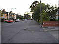
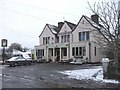
Beulah Road, Cardiff
Beulah Road, Cardiff
Image: © Steve Chapple
Taken: 6 Sep 2005
0.08 miles
3
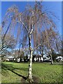
Silver birch
A fine specimen of a weeping silver birch (Betula Pendula) in Charlotte Gardens, Rhiwbina.
Image: © Alan Hughes
Taken: 18 Feb 2021
0.09 miles
4
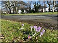
Spring crocuses
Cluster of crocuses in Charlotte Square.
Image: © Alan Hughes
Taken: 18 Feb 2021
0.10 miles
6
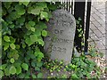
Municipal Boundary Marker on Beulah Road, Rhiwbina
Municipal Boundary Marker on the north side of Beulah Road, beside the driveway to number 47. Rhiwbina parish. Erected to mark the extension of the city and county borough boundary in 1922.
Milestone Society National ID: GLA_RHIWB01pb
Image: © R Guy
Taken: 19 Aug 2021
0.14 miles
7
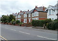
Beulah Road houses, Cardiff
Houses on the north side of Beulah Road, between Cae Mawr Road and the junction with the A469.
Image: © Jaggery
Taken: 12 Aug 2010
0.15 miles
8

Ordnance Survey Cut Mark
This OS cut mark can be found on the wall of No43 Beulah Road. It marks a point 45.482m above mean sea level.
Image: © Adrian Dust
Taken: 26 Feb 2024
0.16 miles
9
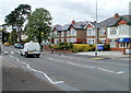
Thornhill Road, Cardiff
Houses on the east side of Thornhill Road, on an unusually long (400 metres) stretch of road, north of Heol Iscoed, with no junctions, on the left or on the right.
Image: © Jaggery
Taken: 12 Aug 2010
0.16 miles
10
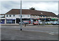
Beulah Road shops, Cardiff
Shops and other business premises arranged in an arc at the eastern end of Beulah Road, opposite the mini-roundabout on the A469 where the northern end of Caerphilly Road becomes the southern end of Thornhill Road.
Image: © Jaggery
Taken: 12 Aug 2010
0.16 miles