IMAGES TAKEN NEAR TO
Grafton Terrace, CARDIFF, CF14 6AU
Introduction
This page details the photographs taken nearby to Grafton Terrace, CF14 6AU by members of the Geograph project.
The Geograph project started in 2005 with the aim of publishing, organising and preserving representative images for every square kilometre of Great Britain, Ireland and the Isle of Man.

There are currently over 7.5m images from over14,400 individuals and you can help contribute to the project by visiting https://www.geograph.org.uk
Image Map
Images are licensed for reuse under creativecommons.org/licenses/by-sa/2.0
Notes
- Clicking on the map will re-center to the selected point.
- The higher the marker number, the further away the image location is from the centre of the postcode.
Image Listing (111 Images Found)
Images are licensed for reuse under creativecommons.org/licenses/by-sa/2.0
Image
Details
Distance
1
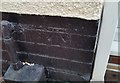
Ordnance Survey Cut Mark
This OS cut mark can be found on No23 Ty Wern Road. It marks a point 38.621m above mean sea level.
Image: © Adrian Dust
Taken: 18 Nov 2018
0.05 miles
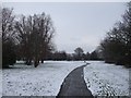
3
Footpath on bridge across the railway line, Birchgrove, Cardiff
A stone bridge carries a footpath from the western edge of Hill Snook Park, heading for Waun-y-Groes Avenue, across the single-track railway line between Rhiwbina and Birchgrove stations.
Image: © Jaggery
Taken: 19 Feb 2010
0.08 miles
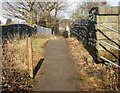
4
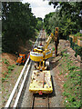
Lineside clearance work on the Coryton line
Lineside-clearance and tree-cutting work is underway between Birchgrove and Rhiwbina stations.
Image: © Gareth James
Taken: 1 Jul 2023
0.11 miles
5
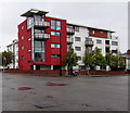
Block of flats on a Rhiwbina corner, Cardiff
On the corner of Pantbach Road and Ty-Wern Road in the Rhiwbina area of Cardiff.
Image: © Jaggery
Taken: 4 Oct 2019
0.12 miles
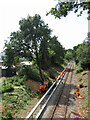
6
Electrification work on the Coryton line near Birchgrove
The view west from the footbridge near Hill Snook Park sees a base for an electrification mast being driven into the ground.
Image: © Gareth James
Taken: 1 Jul 2023
0.12 miles
7
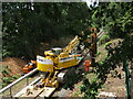
Electrification work on the Coryton line near Birchgrove
The view west from the footbridge near Hill Snook Park sees a base for an electrification mast being driven into the ground.
Image: © Gareth James
Taken: 1 Jul 2023
0.12 miles
8
Electrification work on the Coryton line near Birchgrove
The view west from the footbridge near Hill Snook Park sees a base for an electrification mast being driven into the ground. Also note the shredder in attendance to assist with lineside-vegetation clearance and the relatively new trunking to the left of the track and new fencing to the right.
Image: © Gareth James
Taken: 1 Jul 2023
0.12 miles
9
Ordnance Survey Cut Mark
This OS cut mark can be found on No83 Ty Wern Road. It marks a point 41.291m above mean sea level.
Image: © Adrian Dust
Taken: 18 Nov 2018
0.12 miles
10

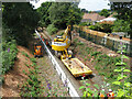
Electrification work on the Coryton line
In recent days, wiring of the electrification on the Coryton line has begun. This is the view east from the footbridge to Hill Snook Park showing the catenary wire in place - note how it zig-zags above the track to even out wear on the trains' pantograph heads. The contact wire would be added within a day or two.
Image: © Gareth James
Taken: 16 Jul 2024
0.12 miles