1
Ordnance Survey Cut Mark
This OS cut mark can be found on No23 Ty Wern Road. It marks a point 38.621m above mean sea level.
Image: © Adrian Dust
Taken: 18 Nov 2018
0.04 miles
2
Homelands Rd., Rhiwbina 1964
View from the bedroom window of my lodgings whilst studying at WCAT (Welsh College of Advanced Technology) in 1963-66. Note that the road into Thornbury Close did not exist then.
Image: © Mike Dodman
Taken: Unknown
0.10 miles
3
Path in Hill Snook Park, Cardiff
Image: © John Lord
Taken: 5 Feb 2009
0.10 miles
4
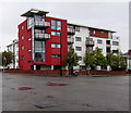
Block of flats on a Rhiwbina corner, Cardiff
On the corner of Pantbach Road and Ty-Wern Road in the Rhiwbina area of Cardiff.
Image: © Jaggery
Taken: 4 Oct 2019
0.10 miles
5
Ordnance Survey Cut Mark
This OS cut mark can be found on No83 Ty Wern Road. It marks a point 41.291m above mean sea level.
Image: © Adrian Dust
Taken: 18 Nov 2018
0.11 miles
6
Birchgrove railway station, Cardiff
Birchgrove railway station, Cardiff
Image: © Steve Chapple
Taken: 20 Aug 2005
0.12 miles
7
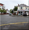
Access shop on a Rhiwbina corner, Cardiff
Access garage door & mobility centre shop is at 90 Ty'n-y-Parc Road on the corner of Pantbach Road.
Image: © Jaggery
Taken: 4 Oct 2019
0.13 miles
8
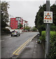
CCTV notice on a Pantbach Road lamppost, Rhiwbina, Cardiff
Text on the notice in October 2019 includes
For the purpose of Crime Prevention and Community Safety.
The text is also in Welsh.
Image: © Jaggery
Taken: 4 Oct 2019
0.14 miles
9
Footpath on bridge across the railway line, Birchgrove, Cardiff
A stone bridge carries a footpath from the western edge of Hill Snook Park, heading for Waun-y-Groes Avenue, across the single-track railway line between Rhiwbina and Birchgrove stations.
Image: © Jaggery
Taken: 19 Feb 2010
0.14 miles
10
Fairfax Road, Cardiff
Image: © Alex McGregor
Taken: 22 Apr 2014
0.15 miles


