
IMAGES TAKEN NEAR TO
Caerphilly Road, CARDIFF, CF14 4NF
Introduction
This page details the photographs taken nearby to Caerphilly Road, CF14 4NF by members of the Geograph project.
The Geograph project started in 2005 with the aim of publishing, organising and preserving representative images for every square kilometre of Great Britain, Ireland and the Isle of Man.

There are currently over 7.5m images from over14,400 individuals and you can help contribute to the project by visiting https://www.geograph.org.uk
Image Map
Images are licensed for reuse under creativecommons.org/licenses/by-sa/2.0
Notes
- Clicking on the map will re-center to the selected point.
- The higher the marker number, the further away the image location is from the centre of the postcode.
Image Listing (106 Images Found)
Images are licensed for reuse under creativecommons.org/licenses/by-sa/2.0
Image
Details
Distance
1
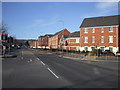
Caerphilly Rd, Cardiff
The apartments on the right are built on the site of the former Royal Ordnance Factory. Towards the end of its existence, this factory made parts for missiles, and so was the occasional scene of anti-nuclear demonstrations. The hill in the distance is Graig Llanishen, on which are the ruins of Castell Morgraig. On the right of the picture can be seen part of the name of the side street, Ffordd Morgraig, presumably named after Castell Morgraig ImageThe road sign actually says Ffordd Mograig, but this is surely a typo.
Image: © John Lord
Taken: 4 Mar 2010
0.01 miles
2
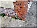
Ordnance Survey Cut Mark
This OS cut mark can be found on No455 Caerphilly Road. It marks a point 41.742m above mean sea level.
Image: © Adrian Dust
Taken: 26 Feb 2024
0.03 miles
3
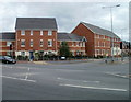
Ffordd Mograig, Cardiff
Recently-built housing on the corner of Caerphilly Road and Ffordd Mograig.
Image: © Jaggery
Taken: 12 Aug 2010
0.06 miles
4

Caerphilly Road, Cardiff
View north along Caerphilly Road, after recent snowfall.
Image: © Gareth James
Taken: 2 Mar 2018
0.09 miles
5
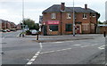
Former Thresher off-licence, Caerphilly Road, Cardiff
Vacant premises at 493 Caerphilly Road, on the corner of Beulah Road.
Nationwide, more than a thousand Thresher off-licence stores closed at the end of 2009, with the loss of several thousand jobs, after the company entered administration.
Image: © Jaggery
Taken: 12 Aug 2010
0.10 miles
6
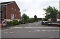
Junction at the western end of Smith Road, Cardiff
Smith Road leads to Pentland Close. Except for buses, Smith Road is not a through route for motor vehicles.
Image: © Jaggery
Taken: 21 Jun 2016
0.11 miles
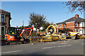
8
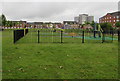
Children's play area north of Smith Road, Cardiff
Opposite Llys Enfys. http://www.geograph.org.uk/photo/5011044
Image: © Jaggery
Taken: 21 Jun 2016
0.12 miles
9
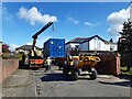
Container removal in Rhiwbina
A container used during gas-pipe work is removed from a sideroad in Rhiwbina.
Image: © Gareth James
Taken: 19 Apr 2022
0.12 miles
10
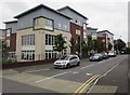
Ffordd Mograig, Cardiff
Looking south along the road named Ffordd Mograig from the corner of Smith Road.
A nearby street name sign shows that Ffordd Mograig leads to Tasker Square.
Image: © Jaggery
Taken: 21 Jun 2016
0.13 miles