1
College Road Lock Location
The lane is the old the towpath of the Glamorganshire Canal and the rise in it marks the location of College Road Lock.
Image: © Guy Butler-Madden
Taken: 25 Feb 2006
0.01 miles
2
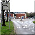
Directions sign facing Gabalfa Avenue, Llandaff North, Cardiff
On the approach to the Gabalfa Road roundabout opposite Ysgol Gyfun Gymraeg Glantaf, a Welsh-medium secondary school.
Image: © Jaggery
Taken: 18 Apr 2016
0.02 miles
3
Telecoms cabinets, Gabalfa Road, Llandaff North, Cardiff
Alongside a hedge at the edge of Ysgol Gyfun Gymraeg Glantaf, a Welsh-medium secondary school.
In April 2016, a BT notice on the cabinet on the left states Fibre broadband is here.
Image: © Jaggery
Taken: 18 Apr 2016
0.02 miles
4
Mini-roundabout, Llandaff North, Cardiff
At the junction of Gabalfa Road and Gabalfa Avenue (ahead).
Image: © Jaggery
Taken: 18 Apr 2016
0.02 miles
5
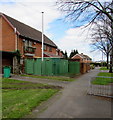
Wales & West Utilities gas installation, Gabalfa Avenue, Llandaff North, Cardiff
Inside a green enclosure on the north side of Gabalfa Avenue, near the Gabalfa Road junction.
Image: © Jaggery
Taken: 18 Apr 2016
0.02 miles
6
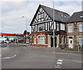
Disraeli House formerly the Cow and Snuffers pub, Llandaff North, Cardiff
Viewed in April 2016. The former Cow and Snuffers pub, seen here http://www.geograph.org.uk/photo/1694536 in February 2010, has been converted to flats. The COW AND SNUFFERS name below the top floor window has been retained.
Image: © Jaggery
Taken: 18 Apr 2016
0.03 miles
7
Row of stone houses, Gabalfa Road, Llandaff North, Cardiff
Extending for 40 metres from the corner of Gabalfa Avenue towards the A4054 Station Road.
Image: © Jaggery
Taken: 18 Apr 2016
0.03 miles
8
Cow and Snuffers
The Cow and Snuffers, Llandaff North. Opened 1812, closed 2010.
Image: © Alan Hughes
Taken: 7 Apr 2016
0.03 miles
9
Cow and Snuffers Pub
The Glamorganshire Canal ran behind the pub on its way to Cardiff.
Llandaff lock was in the middle of the road which originally passed over the canal between the lock and the pub. For an old photo of the pub see http://www.lightmoor.co.uk/BDLbooksample_pics/B9129_samp1.jpg
The existing lock cottage
Image is just out of view on the right of the photo.
Image: © Guy Butler-Madden
Taken: 15 Mar 2010
0.03 miles
10
Ki Aikido, Llandaff North, Cardiff
One of the names on the Gabalfa Avenue side of All Saints Church Hall is Ki Aikido.
The hall is the meeting place of Cardiff Ki Aikido Club.
The other name is Little Footprints Playgroup (childcare for pre-school children aged 2 and older).
All Saints' Church http://www.geograph.org.uk/photo/4913539 is on the right.
Image: © Jaggery
Taken: 18 Apr 2016
0.03 miles


