IMAGES TAKEN NEAR TO
Clos Newydd, CARDIFF, CF14 2BA
Introduction
This page details the photographs taken nearby to Clos Newydd, CF14 2BA by members of the Geograph project.
The Geograph project started in 2005 with the aim of publishing, organising and preserving representative images for every square kilometre of Great Britain, Ireland and the Isle of Man.

There are currently over 7.5m images from over14,400 individuals and you can help contribute to the project by visiting https://www.geograph.org.uk
Image Map
Images are licensed for reuse under creativecommons.org/licenses/by-sa/2.0
Notes
- Clicking on the map will re-center to the selected point.
- The higher the marker number, the further away the image location is from the centre of the postcode.
Image Listing (86 Images Found)
Images are licensed for reuse under creativecommons.org/licenses/by-sa/2.0
Image
Details
Distance
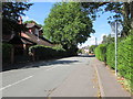
1
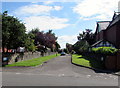
Clos Newydd, Whitchurch, Cardiff
Cul-de-sac on the east side of the A4054 Heol Don.
Image: © Jaggery
Taken: 10 Aug 2017
0.01 miles
2
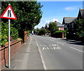
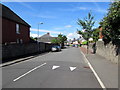
Warning sign - road narrows, Heol Don, Whitchurch, Cardiff
Facing northbound traffic on Heol Don near an English/Welsh SLOW/ARAF painted on the road surface.
Image: © Jaggery
Taken: 10 Aug 2017
0.06 miles
3

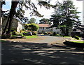
Heol Don Care Home, Whitchurch, Cardiff
Purpose-built Bupa care home set back 80 metres from the east side of the road named Heol Don.
The 78-bedroom home provides residential, nursing and dementia care.
Bupa (originally the British United Provident Association) is an international healthcare group based in London.
Image: © Jaggery
Taken: 10 Aug 2017
0.07 miles
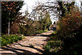
5
Barriered drive - Whitchurch
The drive leads toward an area occupied by a schools complex but a sign warns that the structure this approaches is unsafe and that danger lies beyond..
Image: © Mick Lobb
Taken: 15 Apr 2010
0.07 miles
6
Firwood Close, Whitchurch, Cardiff
Cul-de-sac on the east side of the A4054 Heol Don.
Image: © Jaggery
Taken: 10 Aug 2017
0.08 miles
7
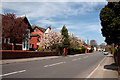
Athelstan Road, Whitchurch, Cardiff
West along Athelstan Road from the corner of Heol Don.
Painted white triangles draw attention to the speed bump.
Image: © Jaggery
Taken: 10 Aug 2017
0.09 miles
8
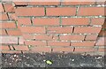
Ordnance Survey Cut Mark
This OS cut mark can be found on the wall of No33 Heol Don. It marks a point 32.894m above mean sea level.
Image: © Adrian Dust
Taken: 4 Mar 2024
0.10 miles
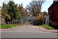
9
Heol Don - Whitchurch
At this point Heol Don is a section of the A4054. Just after the approaching bend it branches to the left and is joined from the right by Kelston Road which then becomes the A4054 for a short distance of 363 m.
Image: © Mick Lobb
Taken: 15 Apr 2010
0.10 miles
10
Alfreda Road, Whitchurch, Cardiff
West along Alfreda Road from the corner of Heol Don.
Image: © Jaggery
Taken: 10 Aug 2017
0.11 miles