1
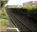
East along the Coryton Line from Whitchurch (Cardiff) railway station
Next station ahead on the single-track branch line is Rhiwbina.
Image: © Jaggery
Taken: 9 Oct 2019
0.04 miles
2
Whitchurch Station, Cardiff, looking east
Image: © John Lord
Taken: 5 Feb 2009
0.04 miles
3
East along Whitchurch (Cardiff) railway station
Unstaffed single-platform station on the Coryton Line branch line.
In October 2019 the station is managed by Transport for Wales,
the company which operates all passenger trains on the Coryton Line.
Image: © Jaggery
Taken: 9 Oct 2019
0.05 miles
4
Whitchurch Railway Station, Cardiff
Viewed from the A470 road bridge over the Cardiff-Coryton railway line.
Image: © Martyn Harries
Taken: 3 Nov 2009
0.05 miles
5
Whitchurch Station, Cardiff, looking west
Image: © John Lord
Taken: 5 Feb 2009
0.05 miles
6
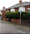
Houses, hedges, low walls and cabinets, Caedelyn Road, Cardiff
Viewed from near the corner of the A470 in the Whitchurch area of Cardiff.
Image: © Jaggery
Taken: 6 Nov 2019
0.05 miles
7
The A470 towards Junction 32 , M4 motorway
This picture was taken around midday with hardly any traffic on the dual carriageway.
Image: © Martyn Harries
Taken: 15 Sep 2009
0.05 miles
8
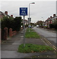
End of cycle route sign, Caedelyn Road, Whitchurch, Cardiff
The bilingual sign on the left here https://www.geograph.org.uk/photo/6318950 shows that END OF ROUTE is DIWEDD Y LLWYBR in Welsh.
Image: © Jaggery
Taken: 6 Nov 2019
0.05 miles
9
Whitchurch railway station, Cardiff
Looking east along the only platform on Whitchurch railway station. The next station in this direction is Rhiwbina, on the way to Cardiff Central. In the opposite direction, the next station is Coryton, http://www.geograph.org.uk/photo/1715623 the end of the line.
Image: © Jaggery
Taken: 19 Feb 2010
0.06 miles
10
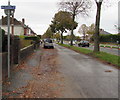
All cyclists direction sign, Ash Grove, Whitchurch, Cardiff
The small white-on-blue sign shows All cyclists and the Welsh Pob beicwyr.
Image: © Jaggery
Taken: 6 Nov 2019
0.06 miles


