IMAGES TAKEN NEAR TO
Fields Park Road, CARDIFF, CF11 9LB
Introduction
This page details the photographs taken nearby to Fields Park Road, CF11 9LB by members of the Geograph project.
The Geograph project started in 2005 with the aim of publishing, organising and preserving representative images for every square kilometre of Great Britain, Ireland and the Isle of Man.

There are currently over 7.5m images from over14,400 individuals and you can help contribute to the project by visiting https://www.geograph.org.uk
Image Map
Images are licensed for reuse under creativecommons.org/licenses/by-sa/2.0
Notes
- Clicking on the map will re-center to the selected point.
- The higher the marker number, the further away the image location is from the centre of the postcode.
Image Listing (78 Images Found)
Images are licensed for reuse under creativecommons.org/licenses/by-sa/2.0
Image
Details
Distance
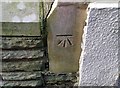
2
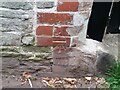
Ordnance Survey Cut Mark
This OS cut mark can be found on the building at the rear of No21 Dogo Street. It marks a point 10.775m above mean sea level.
Image: © Adrian Dust
Taken: 23 Sep 2021
0.05 miles
3
Tua chanol y ddinas / Towards the city centre
Image: © Ceri Thomas
Taken: 14 Jul 2024
0.07 miles
4
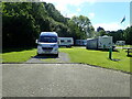
Cardiff Camping and Caravan Site
Centrally situated, near Sofia Gardens and Pontcanna Fields
Image: © Eirian Evans
Taken: 25 May 2021
0.07 miles
5
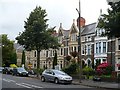
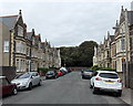
Cathedral Road
A terrace of large Edwardian houses at the northern end of Cathedral Road, some of which are hotels.
Image: © Robin Drayton
Taken: 22 Jul 2009
0.09 miles
6
Ordnance Survey Cut Mark
This OS cut mark can be found on No15 Kyveilog Road. It marks a point 10.147m above mean sea level.
Image: © Adrian Dust
Taken: 15 Oct 2017
0.09 miles
7
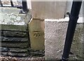
Ordnance Survey Cut Mark
This OS cut mark can be found on No15 Kyveilog Street. It marks a point 33.27ft above mean sea level.
Image: © Adrian Dust
Taken: 23 Sep 2021
0.09 miles
8
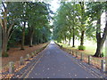
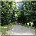
Tree avenue, Pontcanna Fields
An avenue of limes and elms, planted in 1879-80 by Andrew Pettigrew, Head Gardener to the Marquis of Bute, running north-south the length of the park.
Image: © Eirian Evans
Taken: 5 Oct 2015
0.09 miles
9
Kyveilog Street, Cardiff
Looking towards the NE end of the street. Cathedral Road is 50 metres behind the camera. The spelling Kyveilog looks like a 19th century Anglicisation of a Welsh place name, perhaps Caefaelog or similar.
Image: © Jaggery
Taken: 26 May 2014
0.09 miles
10
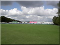
Eisteddfod 2008
Yn 2008 daeth yr Eisteddfod Genedlaethol i'r prif ddinas - in 2008 the National Eisteddfod came to the capital city - http://www.eisteddfod.org.uk/. This shows the Maes (field) in its location on the banks of the River Taf, or Taff.
Image: © Patrick
Taken: 7 Aug 2008
0.11 miles