IMAGES TAKEN NEAR TO
Cathedral Road, CARDIFF, CF11 9HE
Introduction
This page details the photographs taken nearby to Cathedral Road, CF11 9HE by members of the Geograph project.
The Geograph project started in 2005 with the aim of publishing, organising and preserving representative images for every square kilometre of Great Britain, Ireland and the Isle of Man.

There are currently over 7.5m images from over14,400 individuals and you can help contribute to the project by visiting https://www.geograph.org.uk
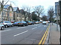
Image Map (Loading...)


Getting Data...Please wait
Leaflet Map data © OpenStreetMap
Images are licensed for reuse under creativecommons.org/licenses/by-sa/2.0
Notes
- Clicking on the map will re-center to the selected point.
- The higher the marker number, the further away the image location is from the centre of the postcode.
Image Listing (111 Images Found)
Images are licensed for reuse under creativecommons.org/licenses/by-sa/2.0
Image
Details
Distance
1
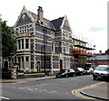
Cathedral 73, Cardiff
Small hotel at 73 Cathedral Road, on the corner of Plasturton Place.
Image: © Jaggery
Taken: 26 May 2014
0.03 miles
2
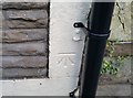
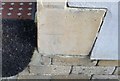
Ordnance Survey Cut Mark
This OS cut mark can be found on No75 Cathedral Road. It marks a point 8.861m above mean sea level.
Image: © Adrian Dust
Taken: 15 Oct 2017
0.04 miles
3

The Cricketers, Cardiff
Opened in 2010, The Cricketers is a pub 66 Cathedral Road, near the cricket ground at the SWALEC stadium.
Image: © Jaggery
Taken: 26 May 2014
0.04 miles
4
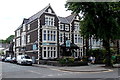
Beverley Hotel, Cardiff
Hotel and bar at 75-77 Cathedral Road, on the corner of Plasturton Place.
Image: © Jaggery
Taken: 26 May 2014
0.04 miles
5
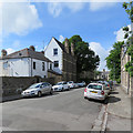
Cardiff: Plasturton Place
Looking towards Plasturton Gardens and the corner of Ryder Street on a bright May morning.
Image: © John Sutton
Taken: 21 May 2017
0.05 miles
6
Cathedral Road, Cardiff
The A4119, Cathedral Road, in Cardiff. Flanked on either side by large Edwardian houses, many of which are now hotels and guesthouses.
Image: © Eirian Evans
Taken: 23 Feb 2008
0.06 miles
7
Ordnance Survey Cut Mark
This OS cut mark can be found on No29 Ryder Street. It marks a point 9.132m above mean sea level.
Image: © Adrian Dust
Taken: 15 Oct 2017
0.06 miles
8
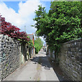
Cardiff: back alley behind Plasturton Gardens
The longer gardens of the more substantial houses on Cathedral Road are to the right.
Image: © John Sutton
Taken: 21 May 2017
0.06 miles
9
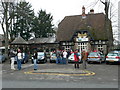
Y Mochyn Du, Gerddi Sophia
Located opposite the Institute for Sport and the Glamorgan Cricket fields in Sophia Gardens, this pub is a popular haunt with the mainly Welsh-speaking residents of Pontcanna and Welsh speakers throughout Cardiff. It is especially popular during the Rugby Six Nations matches.
Image: © Eirian Evans
Taken: 23 Feb 2008
0.07 miles
10
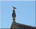
Cardiff: gull, finial and evening sunlight
On one of the stately three-storey Victorian houses on Cathedral Road.
Image: © John Sutton
Taken: 19 May 2017
0.07 miles