IMAGES TAKEN NEAR TO
Severn Road, CARDIFF, CF11 9FE
Introduction
This page details the photographs taken nearby to Severn Road, CF11 9FE by members of the Geograph project.
The Geograph project started in 2005 with the aim of publishing, organising and preserving representative images for every square kilometre of Great Britain, Ireland and the Isle of Man.

There are currently over 7.5m images from over14,400 individuals and you can help contribute to the project by visiting https://www.geograph.org.uk
Image Map
Images are licensed for reuse under creativecommons.org/licenses/by-sa/2.0
Notes
- Clicking on the map will re-center to the selected point.
- The higher the marker number, the further away the image location is from the centre of the postcode.
Image Listing (69 Images Found)
Images are licensed for reuse under creativecommons.org/licenses/by-sa/2.0
Image
Details
Distance
1
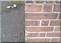
Ordnance Survey Cut Mark
This OS cut mark can be found on the Calvary Baptist Church. It marks a point 8.004m above mean sea level.
Image: © Adrian Dust
Taken: 15 Oct 2017
0.04 miles
2
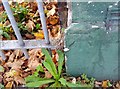
Ordnance Survey Cut Mark
This OS cut mark can be found on the Electricity Distribution building on Severn Road. It marks a point 8.620m above mean sea level.
Image: © Adrian Dust
Taken: 15 Oct 2017
0.05 miles
3
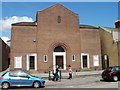
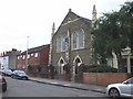
Calvary Baptist church, Canton, Cardiff
Calvary Baptist Church was formed on January 1st 1972 by the merging of the two Baptist fellowships of Hope, Canton and Victoria, Riverside.
The Calvary church shown here occupies the former Hope building at 134 Cowbridge Road East, Canton.
Image: © Jaggery
Taken: 22 Jul 2010
0.05 miles
4
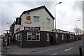
The Admiral Napier Pub - Canton Cardiff
The Admiral Napier Pub - Canton Cardiff taken Feb 2010
Image: © Eddie Reed
Taken: 6 Feb 2010
0.05 miles
5
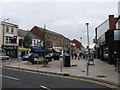
Shops in Canton, Cardiff
Looking towards Cowbridge Road East.
Image: © Gareth James
Taken: 7 Jul 2010
0.06 miles

7

Ordnance Survey Cut Mark
This OS cut mark can be found on the No181 Cowbridge Road East which was once The Foresters Arms and now a charity shop. It marks a point 7.559m above mean sea level.
Image: © Adrian Dust
Taken: 23 Sep 2021
0.09 miles
8
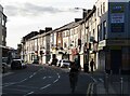
Cardiff - Cowbridge Road East
Inner city suburban shopping centre and through road in Cardiff's district of Canton.
www.cardiff.gov.uk
Image: © Colin Smith
Taken: 10 Oct 2021
0.09 miles
10
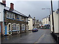
Canton Cross Vaults
Attractive stone pub in the Canton district of west Cardiff, just off Cowbridge Road at Delta Street.
Image: © Colin Smith
Taken: 27 May 2007
0.10 miles