IMAGES TAKEN NEAR TO
Wyndham Road, CARDIFF, CF11 9EJ
Introduction
This page details the photographs taken nearby to Wyndham Road, CF11 9EJ by members of the Geograph project.
The Geograph project started in 2005 with the aim of publishing, organising and preserving representative images for every square kilometre of Great Britain, Ireland and the Isle of Man.

There are currently over 7.5m images from over14,400 individuals and you can help contribute to the project by visiting https://www.geograph.org.uk
Image Map
Images are licensed for reuse under creativecommons.org/licenses/by-sa/2.0
Notes
- Clicking on the map will re-center to the selected point.
- The higher the marker number, the further away the image location is from the centre of the postcode.
Image Listing (85 Images Found)
Images are licensed for reuse under creativecommons.org/licenses/by-sa/2.0
Image
Details
Distance
1
Ordnance Survey Cut Mark
This OS cut mark can be found on the SE angle of the Roman Catholic School. It marks a point 8.239m above mean sea level.
Image: © Adrian Dust
Taken: 11 Nov 2017
0.05 miles
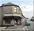
2
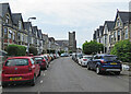
Cardiff: along King's Road
Looking towards the Roman Catholic Church of St Mary of the Angels on the corner of Talbot Street.
Image: © John Sutton
Taken: 13 Jul 2022
0.05 miles
4
Ordnance Survey Cut Mark
This OS cut mark can be found on the Electricity Distribution building on Severn Road. It marks a point 8.620m above mean sea level.
Image: © Adrian Dust
Taken: 15 Oct 2017
0.10 miles
5
Cardiff - Brod
A fashionable Danish bakery/cafe at the Pontcanna end of Wyndham Crescent.
www.thedanishbakery.co.uk
Image: © Colin Smith
Taken: 29 Feb 2020
0.10 miles
6
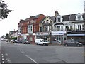
Shops at junction of Severn Rd and Romilly Crescent, Cardiff
Image: © John Lord
Taken: 26 Aug 2008
0.10 miles
7
Cardiff: south along Pitman Street
A May-morning view from the corner of Plasturton Gardens.
Image: © John Sutton
Taken: 21 May 2017
0.11 miles
8

Kings Road, Cardiff
An advert for C. E. Watts Boot Repairing Depot (Estb. 1898) adorns the end of what is now just another house
Image: © Keith Edkins
Taken: 20 Jun 2009
0.11 miles
9
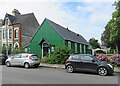
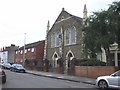
Cardiff: St Catherine's Church Hall
A corrugated hall on King's Road. The nearby church was consecrated in 1885.
Image: © John Sutton
Taken: 13 Jul 2022
0.11 miles
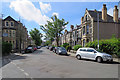
10
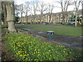
Cardiff - Plasturton Gardens
Desirable residential area of Pontcanna, close to Sophia Gardens and a film location for "His Dark Materials".
www.cardiff.gov.uk
Image: © Colin Smith
Taken: 1 Mar 2020
0.11 miles