IMAGES TAKEN NEAR TO
Talbot Place, CARDIFF, CF11 9BY
Introduction
This page details the photographs taken nearby to Talbot Place, CF11 9BY by members of the Geograph project.
The Geograph project started in 2005 with the aim of publishing, organising and preserving representative images for every square kilometre of Great Britain, Ireland and the Isle of Man.

There are currently over 7.5m images from over14,400 individuals and you can help contribute to the project by visiting https://www.geograph.org.uk
Image Map
Images are licensed for reuse under creativecommons.org/licenses/by-sa/2.0
Notes
- Clicking on the map will re-center to the selected point.
- The higher the marker number, the further away the image location is from the centre of the postcode.
Image Listing (105 Images Found)
Images are licensed for reuse under creativecommons.org/licenses/by-sa/2.0
Image
Details
Distance
1
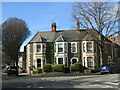
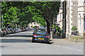
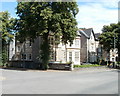
Cardiff - Talbot Street
Desirable residential area of Pontcanna, close to Sophia Gardens.
www.cardiff.gov.uk
Image: © Colin Smith
Taken: 1 Mar 2020
0.01 miles
2
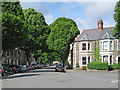
Cardiff: the corner of Talbot Street and Ryder Street
A sunny Sunday morning in May.
Image: © John Sutton
Taken: 21 May 2017
0.02 miles
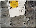
3
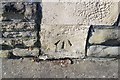
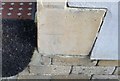
Ordnance Survey Cut Mark
This OS cut mark can be found on No48 Ryder Street. It marks a point 8.483m above mean sea level.
Image: © Adrian Dust
Taken: 15 Oct 2017
0.02 miles
4
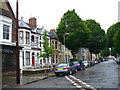
Talbot Street
Leafy up-market terraced housing scene just off Cathedral Road [to Llandaff], Cardiff. The houses are of brick and stone.
Image: © Colin Smith
Taken: 27 May 2007
0.03 miles
5
Cardiff: along leafy Talbot Street
Sunday morning in one of the prosperous-looking streets west of Cathedral Road.
Image: © John Sutton
Taken: 21 May 2017
0.03 miles
6
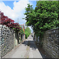
Cardiff: back alley behind Plasturton Gardens
The longer gardens of the more substantial houses on Cathedral Road are to the right.
Image: © John Sutton
Taken: 21 May 2017
0.03 miles
7
Ordnance Survey Cut Mark
This OS cut mark can be found on No34 Talbot Street. It marks a point 8.784m above mean sea level.
Image: © Adrian Dust
Taken: 15 Oct 2017
0.06 miles
8
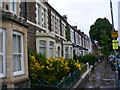
Ryder Street
Terraced stone housing with bay windows, parallel to Cardiff's Cathedral Road.
Image: © Colin Smith
Taken: 27 May 2007
0.07 miles
9
Sophia Close, Cardiff
A corner of Sophia Close, viewed across Cathedral Road.
Image: © Jaggery
Taken: 22 Jul 2010
0.07 miles
10
Ordnance Survey Cut Mark
This OS cut mark can be found on No29 Ryder Street. It marks a point 9.132m above mean sea level.
Image: © Adrian Dust
Taken: 15 Oct 2017
0.07 miles