IMAGES TAKEN NEAR TO
Corporation Road, CARDIFF, CF11 7AS
Introduction
This page details the photographs taken nearby to Corporation Road, CF11 7AS by members of the Geograph project.
The Geograph project started in 2005 with the aim of publishing, organising and preserving representative images for every square kilometre of Great Britain, Ireland and the Isle of Man.

There are currently over 7.5m images from over14,400 individuals and you can help contribute to the project by visiting https://www.geograph.org.uk
Image Map (Loading...)


Getting Data...Please wait
Leaflet Map data © OpenStreetMap
Images are licensed for reuse under creativecommons.org/licenses/by-sa/2.0
Notes
- Clicking on the map will re-center to the selected point.
- The higher the marker number, the further away the image location is from the centre of the postcode.
Image Listing (69 Images Found)
Images are licensed for reuse under creativecommons.org/licenses/by-sa/2.0
Image
Details
Distance
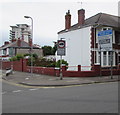
1
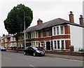
Taff Terrace, Cardiff
Taff Terrace heads away from Corporation Road towards Taff Embankment.
Image: © Jaggery
Taken: 5 Feb 2010
0.01 miles
2
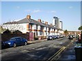
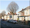
Row of houses, Corporation Road, Grangetown, Cardiff
Viewed across the A4119 Corporation Road opposite the Taff Terrace junction.
Image: © Jaggery
Taken: 10 Jun 2017
0.01 miles
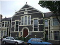
3
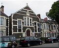
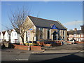
Ebenezer Church, Grangetown, Cardiff
The Corporation Road church is between Taff Terrace and Abercynon Street. The inscription around the door archway is ALL ARE WELCOME and above the 3 central windows, 1899 EBENEZER HALL.
Image: © Jaggery
Taken: 10 Jun 2017
0.02 miles
4
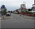
Junction of Corporation Road and Taff Terrace, Grangetown, Cardiff
Signs facing the A4119 Corporation Road show that vehicles entering Taff Terrace have priority over oncoming vehicles, and no vehicles heavier than 7.5 tonnes in Taff Terrace except for access.
Image: © Jaggery
Taken: 10 Jun 2017
0.02 miles
5
A4119 directions sign, Grangetown, Cardiff
Alongside the A4119 Corporation Road near the Taff Terrace junction.
Image: © Jaggery
Taken: 10 Jun 2017
0.02 miles
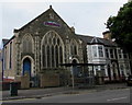
6
Ebenezer Gospel Hall, Corporation Rd, Cardiff
Marked on the 1:25000 OS map, but not, for some reason, on the 1:50000
Image: © John Lord
Taken: 19 May 2010
0.05 miles
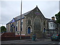
7
North side of the Salvation Army church, Grangetown, Cardiff
The Corporation Road side of this http://www.geograph.org.uk/photo/5422842 church.
Image: © Jaggery
Taken: 10 Jun 2017
0.05 miles
8
Salvation Army citadel, Corporation Rd, Cardiff
Image: © John Lord
Taken: 19 May 2010
0.06 miles
9
Corporation Road, Cardiff
A view NW along the SE end of Corporation Road.
Image: © Jaggery
Taken: 5 Feb 2010
0.07 miles
10
Grangetown citadel, Cardiff
The Salvation Army's Grangetown citadel (meeting hall) is located at the junction of Corporation Road and Avondale Road.
Image: © Jaggery
Taken: 5 Feb 2010
0.07 miles