IMAGES TAKEN NEAR TO
South Morgan Place, CARDIFF, CF11 6FY
Introduction
This page details the photographs taken nearby to South Morgan Place, CF11 6FY by members of the Geograph project.
The Geograph project started in 2005 with the aim of publishing, organising and preserving representative images for every square kilometre of Great Britain, Ireland and the Isle of Man.

There are currently over 7.5m images from over14,400 individuals and you can help contribute to the project by visiting https://www.geograph.org.uk
Image Map (Loading...)


Getting Data...Please wait
Leaflet Map data © OpenStreetMap
Images are licensed for reuse under creativecommons.org/licenses/by-sa/2.0
Notes
- Clicking on the map will re-center to the selected point.
- The higher the marker number, the further away the image location is from the centre of the postcode.
Image Listing (43 Images Found)
Images are licensed for reuse under creativecommons.org/licenses/by-sa/2.0
Image
Details
Distance
1

Bar Sicilia 76 Cowbridge Road east in Canton Cardiff
Photograph taken in Feb 2010
Image: © Eddie Reed
Taken: 6 Feb 2010
0.10 miles
2

Kings Castle, Canton, Cardiff
Pub on the corner of Cowbridge Road East and King's Road.
The pub was open for business at the date of this photo (late July 2010) but there is a For Sale sign affixed to the right side of the pub.
Image: © Jaggery
Taken: 22 Jul 2010
0.10 miles
3

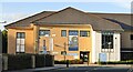
St David's Court Surgery, Canton, Cardiff
Located at 68a Cowbridge Road East. This is a purpose-built surgery with facilities for the disabled.
Image: © Jaggery
Taken: 22 Jul 2010
0.10 miles
4

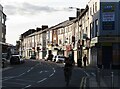
Shops, Cowbridge Road East, Cardiff
This is the eastern end of a long line of shops on both sides of Cowbridge Road East. Seen here is the north side of the road.
Image: © Jaggery
Taken: 22 Jul 2010
0.10 miles
5
Cardiff - St David's Hospital
Community hospital on Cowbridge Road East. Note the "Vaccination Hope" mural - an anti-Covid stance.
www.wales.nhs.uk
Image: © Colin Smith
Taken: 10 Oct 2021
0.11 miles
6

Zio Piero Restaurant 126a Cowbridge Road east Canton Cardiff
This photograph was taken in Feb 2010
Image: © Eddie Reed
Taken: 7 Feb 2010
0.11 miles
7

Ordnance Survey Cut Mark
This OS cut mark can be found on the No181 Cowbridge Road East which was once The Foresters Arms and now a charity shop. It marks a point 7.559m above mean sea level.
Image: © Adrian Dust
Taken: 23 Sep 2021
0.13 miles
8
Cardiff - Cowbridge Road East
Inner city suburban shopping centre and through road in Cardiff's district of Canton.
www.cardiff.gov.uk
Image: © Colin Smith
Taken: 10 Oct 2021
0.13 miles
9

Ordnance Survey Cut Mark
This OS cut mark can be found on No24 Kings Road. It marks a point 7.971m above mean sea level.
Image: © Adrian Dust
Taken: 15 Oct 2017
0.15 miles
10
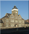
The old St.Davids Hospital, Cardiff.
The front entrance and clock tower are all that remain of original St.Davids Hospital on Cowbridge Road East, Canton, Cardiff.
Image: © Peter Wasp
Taken: 11 Dec 2005
0.15 miles