IMAGES TAKEN NEAR TO
Brunel Street, CARDIFF, CF11 6ES
Introduction
This page details the photographs taken nearby to Brunel Street, CF11 6ES by members of the Geograph project.
The Geograph project started in 2005 with the aim of publishing, organising and preserving representative images for every square kilometre of Great Britain, Ireland and the Isle of Man.

There are currently over 7.5m images from over14,400 individuals and you can help contribute to the project by visiting https://www.geograph.org.uk
Image Map
Images are licensed for reuse under creativecommons.org/licenses/by-sa/2.0
Notes
- Clicking on the map will re-center to the selected point.
- The higher the marker number, the further away the image location is from the centre of the postcode.
Image Listing (96 Images Found)
Images are licensed for reuse under creativecommons.org/licenses/by-sa/2.0
Image
Details
Distance
1
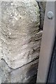
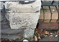
Ordnance Survey Cut Mark
This OS cut mark can be found on the south angle of the Baptist Chapel. It marks a point 7.952m above mean sea level.
Image: © Adrian Dust
Taken: 15 Oct 2017
0.03 miles
2
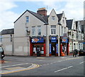
Fish Bazaar, Cardiff
Located on the corner of Ninian Park Road and Stephenson Street. Groceries, off-licence, Caribbean foods.
Image: © Jaggery
Taken: 5 Aug 2010
0.07 miles
3
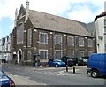
Shiloh Pentecostal Fellowship Cardiff
Church on the corner of Ninian Park Road and Brunel Street. Formerly the Calvary Baptists' Riverside church, the building was vacated in 1972 on the merger with the fellowship in Canton, where the Baptists now worship. http://www.geograph.org.uk/photo/1975992
Image: © Jaggery
Taken: 5 Aug 2010
0.07 miles
4
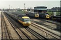
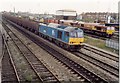
Cardiff Canton
HST 253010 passes Cardiff Canton Depot with a Swansea train. The building to the right is an old water tower.
Image: © David Ashcroft
Taken: 7 Aug 1980
0.09 miles
5
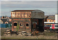
Derelict trackside building Cardiff.
This derelict building is a former steam locomotive water and coaling point. The tank on the roof held water which was fed via nearby 'water cranes' to the tanks and tenders of locos. Coal wagons would have been shunted into the right-hand section and the coal unloaded onto a platform and then discharged into tenders and bunkers of locos, stood on the outside of the building on the side nearest the photographer, through the small openings.
My thanks to John Webb for this information.
Image: © Mick Lobb
Taken: 23 Feb 2009
0.10 miles
7
Ordnance Survey Cut Mark
This OS cut mark can be found on No1 Clare Gardens. It marks a point 8.077m above mean sea level.
Image: © Adrian Dust
Taken: 15 Oct 2017
0.11 miles
9
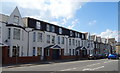
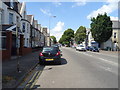
The Wynford Hotel, Cardiff
On Clare Street.
Image: © JThomas
Taken: 14 Jul 2019
0.11 miles
10
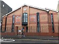
Cardiff: gurdwara and Sikh centre in Tudor Street
The gurdwara has the full name and address on the panel right of centre: "Sri Dasmais Singh Sabha Gurdwara, Bhatra Sikh Centre, 97-103 Tudor Street, Riverside, Cardiff, CF1 8EA" (although the postcodes have been reconfigured since it was put there and it is now CF11 6AE - so the 'CF1' is obsolete and the 'EA' possibly an original error).
Image: © Chris Downer
Taken: 21 Feb 2016
0.11 miles