IMAGES TAKEN NEAR TO
Mount Stuart Square, CARDIFF, CF10 5LG
Introduction
This page details the photographs taken nearby to Mount Stuart Square, CF10 5LG by members of the Geograph project.
The Geograph project started in 2005 with the aim of publishing, organising and preserving representative images for every square kilometre of Great Britain, Ireland and the Isle of Man.

There are currently over 7.5m images from over14,400 individuals and you can help contribute to the project by visiting https://www.geograph.org.uk
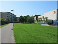
Image Map
Images are licensed for reuse under creativecommons.org/licenses/by-sa/2.0
Notes
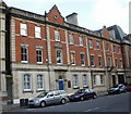
- Clicking on the map will re-center to the selected point.
- The higher the marker number, the further away the image location is from the centre of the postcode.
Image Listing (534 Images Found)
Images are licensed for reuse under creativecommons.org/licenses/by-sa/2.0
Image
Details
Distance
1
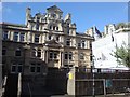
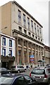
The Coal Exchange
Cardiff was once the world's biggest export port for coal. It's only fitting that the architecture reflect the wealth that the export brought to the area. Built between 1883 and 1886 to the designs of James, Seward and Thomas, this was where many of the most lucrative deals in the world were being made in the early 20th century - indeed, the UK's first million pound cheque was cut in this building.
The millionaires have long since left along with the coal trade. More recently, the Coal Exchange became known as a concert and function venue. However, by October 2007 major renovation was required and it closed. It is hoped to open again in 2009 but this time as luxury flats as well as being a concert venue.
Image: © Hywel Williams
Taken: 4 Jul 2008
0.01 miles
2
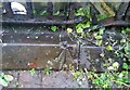
Ordnance Survey Rivet
This OS rivet can be found on the retaining wall of the steps on the west side of the Cardiff Exchange Building. It marks a point 7.847m above mean sea level.
Image: © Adrian Dust
Taken: 14 Sep 2021
0.04 miles
3
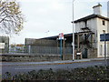
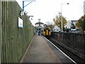
Entrance to Cardiff Bay railway station
The monotony of a long wall http://www.geograph.org.uk/photo/1966126 on the railway (east) side of Bute Street finally ends at the station entrance, near the southern end of the street.
The station (previously Cardiff Bute Road and originally Cardiff Docks) is the southern terminus of the Butetown branch, about 1 mile (1.5 km) south of Cardiff Queen Street station.
Image: © Jaggery
Taken: 24 Oct 2009
0.05 miles
4
Train waiting in Cardiff Bay railway station
Cardiff Bay is the terminus of the short route south from Cardiff Queen Street.
The journeys take 10 minutes, and run every 12 minutes. They need to be timed with great precision, because the southern half of the route is single-track.
At about 180 metres (200 yards) the length of the platform is many times that of the single-carriage service seen here at the buffers end of the station.
Image: © Jaggery
Taken: 24 Oct 2009
0.05 miles
5
West Close, Cardiff
Opposite the entrance http://www.geograph.org.uk/photo/1967282 to Cardiff Bay railway station, West Close heads west away from Bute Street. Although its far side ends in a square, West Close is not a close. There is a connection with Alice Street adjacent to the square.
Image: © Jaggery
Taken: 24 Oct 2009
0.05 miles
6
Enterprise House, Bute Street, Cardiff
Located on the corner of Bute Street and West Bute Street. Now in use as offices, the restored front of the building records its former use as provision curers and bonded store merchants premises.
Image: © Jaggery
Taken: 24 Oct 2009
0.05 miles
7
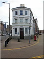
RBS, Cardiff Docks
Royal Bank of Scotland branch, 125 Bute Street, occupying part of a narrow island between Bute Street (on the left) and West Bute Street.
Despite the area now being known generally as Cardiff Bay, the branch retains its Cardiff Docks name.
Image: © Jaggery
Taken: 24 Oct 2009
0.05 miles
8
Meandros House, Cardiff Bay
One of several Grade II listing buildings in the area, this is Meandros House, 54A Bute Street.
Now in use as office buildings, it was formerly the offices of a ship stores company.
Image: © Jaggery
Taken: 24 Oct 2009
0.05 miles
9
113-116 Bute Street, Cardiff
Grade II* listed building, formerly the National Westminster Bank building, built in 1926-1927.
On the left is the Captain Scott pub.http://www.geograph.org.uk/photo/1967549
Image: © Jaggery
Taken: 24 Oct 2009
0.05 miles