1
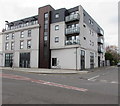
West Close, Butetown, Cardiff
From Bute Street, West Close leads to Alice Street.
Image: © Jaggery
Taken: 20 Nov 2019
0.01 miles
2
Cardiff Bay station
The single platform is about 160 metres long, despite the fact that the train from Cardiff Queen Street usually comprises of just one carriage!
Image: © Richard Sutcliffe
Taken: 8 Jun 2016
0.04 miles
3
Entrance to Cardiff Bay railway station
The monotony of a long wall http://www.geograph.org.uk/photo/1966126 on the railway (east) side of Bute Street finally ends at the station entrance, near the southern end of the street.
The station (previously Cardiff Bute Road and originally Cardiff Docks) is the southern terminus of the Butetown branch, about 1 mile (1.5 km) south of Cardiff Queen Street station.
Image: © Jaggery
Taken: 24 Oct 2009
0.04 miles
4
Train waiting in Cardiff Bay railway station
Cardiff Bay is the terminus of the short route south from Cardiff Queen Street.
The journeys take 10 minutes, and run every 12 minutes. They need to be timed with great precision, because the southern half of the route is single-track.
At about 180 metres (200 yards) the length of the platform is many times that of the single-carriage service seen here at the buffers end of the station.
Image: © Jaggery
Taken: 24 Oct 2009
0.04 miles
5
West Close, Cardiff
Opposite the entrance http://www.geograph.org.uk/photo/1967282 to Cardiff Bay railway station, West Close heads west away from Bute Street. Although its far side ends in a square, West Close is not a close. There is a connection with Alice Street adjacent to the square.
Image: © Jaggery
Taken: 24 Oct 2009
0.04 miles
6
Enterprise House, Bute Street, Cardiff
Located on the corner of Bute Street and West Bute Street. Now in use as offices, the restored front of the building records its former use as provision curers and bonded store merchants premises.
Image: © Jaggery
Taken: 24 Oct 2009
0.04 miles
7
21st century flats on a Butetown corner, Cardiff
On the corner of Bute Street (left side) and West Close.
Image: © Jaggery
Taken: 20 Nov 2019
0.05 miles
8
Enterprise House, Cardiff
Offices at 127-129 Bute Street.
Image: © Jaggery
Taken: 20 Nov 2019
0.05 miles
9
Drope bus, Bute Street, Cardiff
The destination displayed on Cardiff Bus single-decker 232 is Drope via Canton on route 13.
Image: © Jaggery
Taken: 20 Nov 2019
0.05 miles
10
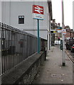
Bilingual Cardiff Bay station name sign
The sign facing Bute Street shows that Cardiff Bay is Bae Caerdydd in Welsh
Image: © Jaggery
Taken: 20 Nov 2019
0.06 miles


