IMAGES TAKEN NEAR TO
CB9 8RB
Introduction
This page details the photographs taken nearby to CB9 8RB by members of the Geograph project.
The Geograph project started in 2005 with the aim of publishing, organising and preserving representative images for every square kilometre of Great Britain, Ireland and the Isle of Man.

There are currently over 7.5m images from over14,400 individuals and you can help contribute to the project by visiting https://www.geograph.org.uk
Image Map
Images are licensed for reuse under creativecommons.org/licenses/by-sa/2.0
Notes
- Clicking on the map will re-center to the selected point.
- The higher the marker number, the further away the image location is from the centre of the postcode.
Image Listing (139 Images Found)
Images are licensed for reuse under creativecommons.org/licenses/by-sa/2.0
Image
Details
Distance
1
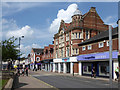
High Street, Haverhill
The northern end. This part has been called Market Hill, but the premises are numbered in the High Street sequence and there is no apparent name plate. Beyond Peacocks, the continuation is called Queen Street. The Argos building was formerly the Co-op, built 1896.
Image: © Robin Webster
Taken: 3 Jun 2018
0.03 miles
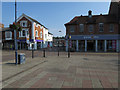
3
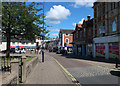
Market Hill, Haverhill
With a closed Argos, relocated to inside a Sainsbury's.
Image: © Hugh Venables
Taken: 6 Jun 2019
0.04 miles
5
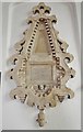
Haverhill - John Ward of Massachusetts
Rev.John Ward helped found Haverhill in Massachusetts, USA. The town was named after the place of his birth in Suffolk.
Image: © Ashley Dace
Taken: 22 Jul 2013
0.04 miles
7
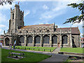
Haverhill church
St. Mary's is a grade II*(star) listed building, 13th/14th century in origin with much later extension and refurbishment.
Image: © Robin Webster
Taken: 3 Jun 2018
0.05 miles
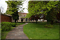
10
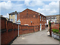
Back of High Street shop, from Quaker's Lane, Haverhill
An unlisted building dated 1839 on the front, which otherwise has a modern shop front on the ground floor. It resembles a chapel or hall. The Quakers' meeting house, now two houses, is off to the near right, so it was not that. A local history site revealed the answer: it was the Market Hill Chapel built to house a break away faction of the Independent Congregational Chapel after a disagreement about finances in 1836. They moved to a new chapel about 1890.
Image: © Robin Webster
Taken: 3 Jun 2018
0.05 miles