IMAGES TAKEN NEAR TO
The Hill, HAVERHILL, CB9 7LD
Introduction
This page details the photographs taken nearby to The Hill, CB9 7LD by members of the Geograph project.
The Geograph project started in 2005 with the aim of publishing, organising and preserving representative images for every square kilometre of Great Britain, Ireland and the Isle of Man.

There are currently over 7.5m images from over14,400 individuals and you can help contribute to the project by visiting https://www.geograph.org.uk
Image Map
Images are licensed for reuse under creativecommons.org/licenses/by-sa/2.0
Notes
- Clicking on the map will re-center to the selected point.
- The higher the marker number, the further away the image location is from the centre of the postcode.
Image Listing (37 Images Found)
Images are licensed for reuse under creativecommons.org/licenses/by-sa/2.0
Image
Details
Distance
1
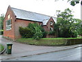
Reading Rooms
The old reading rooms and war memorial at Great Thurlow, Suffolk.
Image: © Keith Evans
Taken: 23 Jun 2011
0.03 miles
2

The old Reading Room, Great Thurlow
The Reading Room was built in 1903 and the clock was named after the Lady Ester the wife of W. F. Smith.
Image: © Adrian S Pye
Taken: 27 Apr 2015
0.03 miles
3
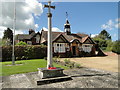
Great Thurlow War Memorial
Great Thurlow War Memorial stands in front of the Old Reading Room.
It bears the five names of men lost in WW1 and of two lost in WW2.
Details can be seen here: http://media.geograph.org.uk/files/fe9fc289c3ff0af142b6d3bead98a923/GREAT_THURLOW_War_Memorial.pdf
Image: © Adrian S Pye
Taken: 27 Apr 2015
0.03 miles
4
Great Thurlow: The Old Reading Room and War Memorial
The Reading Room is dated 1903.
Image: © John Sutton
Taken: 11 Oct 2022
0.03 miles
5
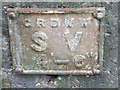
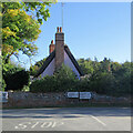
Old Stop Valve Sign
Old stop valve sign at Great Thurlow, Suffolk.
Image: © Keith Evans
Taken: 23 Jun 2011
0.04 miles
6
Estate Offices
The estate office of Thurlow Estates at Great Thurlow, Suffolk.
Image: © Keith Evans
Taken: 23 Jun 2011
0.04 miles
7
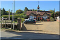
Great Thurlow: signposts, stacks and thatch
This is where the road from Withersfield meets The Street (left) and Wratting Road (right). The Grade II listed thatched house dates from the 17th century.
Image: © John Sutton
Taken: 11 Oct 2022
0.04 miles
8
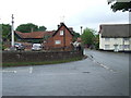
Crossroads
Crossroads and war memorial at Great Thurlow, Suffolk.
Image: © Keith Evans
Taken: 23 Jun 2011
0.04 miles
9
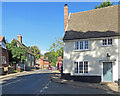
Great Thurlow: at the corner of Bury Road
Looking along The Street. The Grade II listed house on the right was once a pub, The Rose and Crown.
Image: © John Sutton
Taken: 11 Oct 2022
0.05 miles
10
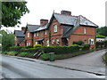
Old Estate Houses
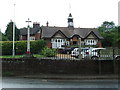
Old houses belonging to the Thurlow Estate at Great Thurlow, Suffolk.
Image: © Keith Evans
Taken: 23 Jun 2011
0.05 miles