IMAGES TAKEN NEAR TO
Orbell Avenue, HAVERHILL, CB9 7JY
Introduction
This page details the photographs taken nearby to Orbell Avenue, CB9 7JY by members of the Geograph project.
The Geograph project started in 2005 with the aim of publishing, organising and preserving representative images for every square kilometre of Great Britain, Ireland and the Isle of Man.

There are currently over 7.5m images from over14,400 individuals and you can help contribute to the project by visiting https://www.geograph.org.uk
Image Map
Images are licensed for reuse under creativecommons.org/licenses/by-sa/2.0
Notes
- Clicking on the map will re-center to the selected point.
- The higher the marker number, the further away the image location is from the centre of the postcode.
Image Listing (5 Images Found)
Images are licensed for reuse under creativecommons.org/licenses/by-sa/2.0
Image
Details
Distance
1
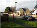
Boyton Woods, Ann Suckling Road
Some of the very newest housing in Haverhill, built in 2013. The yellow house has 4 double bedrooms and is currently on the market at £750,000. The post box is CB9 25.
This area was transferred from Little Wratting parish to Haverhill in 1988.
Image: © Keith Edkins
Taken: 22 Nov 2017
0.17 miles
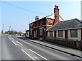
3
'The Fox' public house, on the A.143
Image: © Robert Edwards
Taken: 15 Jan 2007
0.18 miles
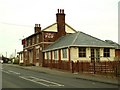
4
Terrace on Wratting Road
These houses are in the parish of Little Wratting. When they were built in the early 20th century they were some way outside the built-up area of Haverhill. The built-up area of Haverhill caught up with them about 1970.
Image: © Keith Edkins
Taken: 22 Nov 2017
0.23 miles
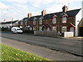
5
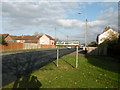
Welcome to Little Wratting?
A slightly misleading sign - the houses visible on the right are indeed in Little Wratting, but those on the left are in Haverhill. The boundary follows the centre line of the road for about 350 metres.
Image: © Keith Edkins
Taken: 22 Nov 2017
0.24 miles