IMAGES TAKEN NEAR TO
Dullingham, NEWMARKET, CB8 9XF
Introduction
This page details the photographs taken nearby to CB8 9XF by members of the Geograph project.
The Geograph project started in 2005 with the aim of publishing, organising and preserving representative images for every square kilometre of Great Britain, Ireland and the Isle of Man.

There are currently over 7.5m images from over14,400 individuals and you can help contribute to the project by visiting https://www.geograph.org.uk
Image Map
Images are licensed for reuse under creativecommons.org/licenses/by-sa/2.0
Notes
- Clicking on the map will re-center to the selected point.
- The higher the marker number, the further away the image location is from the centre of the postcode.
Image Listing (7 Images Found)
Images are licensed for reuse under creativecommons.org/licenses/by-sa/2.0
Image
Details
Distance
1
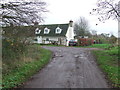
Gipsy Hall
Gipsy Hall near to Burrough Green, Cambridgeshire.
Image: © Keith Evans
Taken: 7 Dec 2015
0.01 miles
2
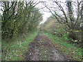
Icknield Way
Looking along part of the Icknield Way near to Burrough Green, Cambridgeshire.
Image: © Keith Evans
Taken: 7 Dec 2015
0.08 miles
3
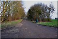
The Icknield Way Trail near Burrough Green
This trail leaves the B1061 heading for Dullingham Ley. It is touch and go which square the first part of the trail is in.
Image: © Mick Malpass
Taken: 14 Mar 2012
0.12 miles
4
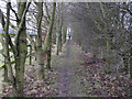
Footpath to Burrough Green
Between horse stud fields.
Image: © Hugh Venables
Taken: 24 Jan 2010
0.17 miles
5
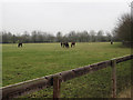
Horses on the stud farm
Default land use in this area.
Image: © Hugh Venables
Taken: 24 Jan 2010
0.24 miles
6

Byway to Burrough End
It also goes to Executive Stud, at which point the good surface for driving ends.
Image: © Hugh Venables
Taken: 24 Jan 2010
0.24 miles
7
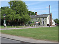
The Bull, Burrough Green
Village pub, serving food.
Image: © Hugh Venables
Taken: 23 May 2009
0.25 miles