IMAGES TAKEN NEAR TO
Stetchworth Road, NEWMARKET, CB8 9UJ
Introduction
This page details the photographs taken nearby to Stetchworth Road, CB8 9UJ by members of the Geograph project.
The Geograph project started in 2005 with the aim of publishing, organising and preserving representative images for every square kilometre of Great Britain, Ireland and the Isle of Man.

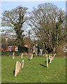
There are currently over 7.5m images from over14,400 individuals and you can help contribute to the project by visiting https://www.geograph.org.uk
Image Map
Images are licensed for reuse under creativecommons.org/licenses/by-sa/2.0
Notes
- Clicking on the map will re-center to the selected point.
- The higher the marker number, the further away the image location is from the centre of the postcode.
Image Listing (92 Images Found)
Images are licensed for reuse under creativecommons.org/licenses/by-sa/2.0
Image
Details
Distance
1
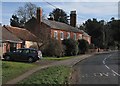
Dullingham: tall chimneys on Stetchworth Road
Clarehall Farmhouse is Grade II listed: see http://www.britishlistedbuildings.co.uk/en-49188-clarehall-farmhouse-dullingham-cambridges .
Image: © John Sutton
Taken: 2 Feb 2015
0.05 miles
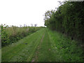
2
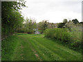
New footpath
Not marked on the map but usefully linking to the footpath to Hope Hall.
Image: © Hugh Venables
Taken: 30 Apr 2010
0.09 miles
3
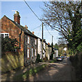
Dullingham: Church Lane
Looking down the hill from the church gate.
Image: © John Sutton
Taken: 2 Feb 2015
0.11 miles
4
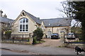
The Old School in Stetchworth Road, Dullingham
This old school is now a private residence as is the school house to the left.
Image: © Mick Malpass
Taken: 14 Mar 2012
0.13 miles
5
Dullingham churchyard and Church Lane
A sunny February morning.
Image: © John Sutton
Taken: 2 Feb 2015
0.13 miles
6
New footpath from Dullingham
Linking with the footpath to Hope Hall.
Image: © Hugh Venables
Taken: 30 Apr 2010
0.14 miles
7
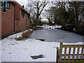
Pond in Dullingham
Mostly frozen but still some Mallards.
Image: © Hugh Venables
Taken: 8 Feb 2009
0.14 miles
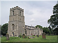
9
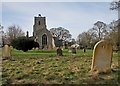
Dullingham: St Mary's Church and churchyard
A winter-morning view from the east end of the churchyard. St Mary's is Grade I listed - see http://www.britishlistedbuildings.co.uk/en-49159-parish-church-of-st-mary-dullingham-cambr .
Image: © John Sutton
Taken: 2 Feb 2015
0.15 miles
10
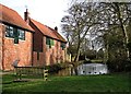
Dullingham Church Pond
The information board explains that the pond, which is up to 7ft deep and was once longer, was originally a Roman dew pond. The houses replace maltings destroyed by a freak tornado in 1991.
Image: © John Sutton
Taken: 2 Feb 2015
0.15 miles