IMAGES TAKEN NEAR TO
Kirtling Road, NEWMARKET, CB8 9SR
Introduction
This page details the photographs taken nearby to Kirtling Road, CB8 9SR by members of the Geograph project.
The Geograph project started in 2005 with the aim of publishing, organising and preserving representative images for every square kilometre of Great Britain, Ireland and the Isle of Man.

There are currently over 7.5m images from over14,400 individuals and you can help contribute to the project by visiting https://www.geograph.org.uk
Image Map
Images are licensed for reuse under creativecommons.org/licenses/by-sa/2.0
Notes
- Clicking on the map will re-center to the selected point.
- The higher the marker number, the further away the image location is from the centre of the postcode.
Image Listing (17 Images Found)
Images are licensed for reuse under creativecommons.org/licenses/by-sa/2.0
Image
Details
Distance
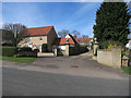
1
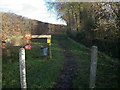
Bridleway through stud farm
With signs warning about the dangers of horses.
Image: © Hugh Venables
Taken: 6 Dec 2008
0.14 miles
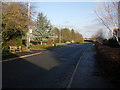
2
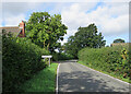
Entering Woodditton
The road from Kirtling Green on a fine September morning.
Image: © John Sutton
Taken: 21 Sep 2023
0.15 miles
3
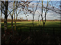
Stud field
Familiar sight in this area south of Newmarket.
Image: © Hugh Venables
Taken: 6 Dec 2008
0.18 miles
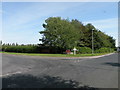
4
Woodditton
Looking towards the central crossroads.
Image: © Hugh Venables
Taken: 6 Dec 2008
0.20 miles
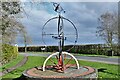
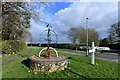
5
Woodditton crossroads
See Image for details of the central feature
Image: © Keith Edkins
Taken: 3 Sep 2018
0.20 miles
6
Feature at Woodditton crossroads
The upper part appears to be a model of an orrery, with a golden globe sun and several grey globe planets
Image: © Keith Edkins
Taken: 3 Sep 2018
0.20 miles
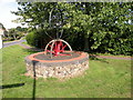
7
Woodditton: Village 'sign' at the crossroads
Image: © Michael Garlick
Taken: 26 Mar 2023
0.21 miles
8
Woodditton: Village 'sign' at the crossroads
Image: © Michael Garlick
Taken: 26 Mar 2023
0.21 miles