IMAGES TAKEN NEAR TO
Water Lane, NEWMARKET, CB8 9LJ
Introduction
This page details the photographs taken nearby to Water Lane, CB8 9LJ by members of the Geograph project.
The Geograph project started in 2005 with the aim of publishing, organising and preserving representative images for every square kilometre of Great Britain, Ireland and the Isle of Man.

There are currently over 7.5m images from over14,400 individuals and you can help contribute to the project by visiting https://www.geograph.org.uk
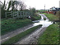
Image Map
Images are licensed for reuse under creativecommons.org/licenses/by-sa/2.0
Notes
- Clicking on the map will re-center to the selected point.
- The higher the marker number, the further away the image location is from the centre of the postcode.
Image Listing (13 Images Found)
Images are licensed for reuse under creativecommons.org/licenses/by-sa/2.0
Image
Details
Distance
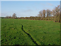
1
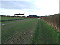
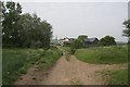
Stour Valley Path
Stour valley path looking west near to Great Bradley, Suffolk.
Image: © Keith Evans
Taken: 16 Jan 2014
0.01 miles
2
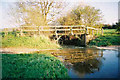
Water Lane Ford, Great Bradley, Suffolk
the other version is better
Image: © mike
Taken: Unknown
0.02 miles
3
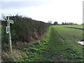
Footpath And Sign
Footpath and footpath sign part of the Stour Valley long distance footpath near to Great Bradley, Suffolk.
Image: © Keith Evans
Taken: 16 Jan 2014
0.03 miles
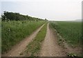
4
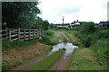
Ford on the Stour at Great Bradley
This ford is found down Water Lane. A video of the ford can be seen at:
https://youtu.be/XtVSZhd-hz0
Image: © John Walton
Taken: 8 Jul 2012
0.04 miles
5
Ford
Ford crossing The River Stour this part of the footpath forms part of the Stour Valley footpath seen near to Great Bradley, Suffolk.
Image: © Keith Evans
Taken: 16 Jan 2014
0.04 miles
6
End of Water Lane
There is a ford where the road becomes a track. A couple of homes at the end of the lane, one of which looks like a barn conversion.
Image: © Hugh Venables
Taken: 31 May 2008
0.05 miles
7
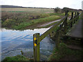
Footbridge and Ford
Crossing the River Stour at the end of Water Lane.
Image: © Hugh Venables
Taken: 6 Dec 2008
0.06 miles
8
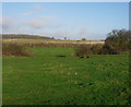
Stour Valley
Looking over the Stour from the footpath, towards Plunder Wood.
Image: © Hugh Venables
Taken: 6 Dec 2008
0.10 miles
9
Footpath along River Stour
But not the Stour Valley Path, which heads north up Kirtling Brook just east of here.
Image: © Hugh Venables
Taken: 6 Dec 2008
0.12 miles
10
Stour Valley Path
At this point the Stour Valley Path heads north along the Kirtling Brook, a tributary of the Stour.
Image: © Hugh Venables
Taken: 31 May 2008
0.12 miles