IMAGES TAKEN NEAR TO
Lords Lane, NEWMARKET, CB8 8TX
Introduction
This page details the photographs taken nearby to Lords Lane, CB8 8TX by members of the Geograph project.
The Geograph project started in 2005 with the aim of publishing, organising and preserving representative images for every square kilometre of Great Britain, Ireland and the Isle of Man.

There are currently over 7.5m images from over14,400 individuals and you can help contribute to the project by visiting https://www.geograph.org.uk
Image Map
Images are licensed for reuse under creativecommons.org/licenses/by-sa/2.0
Notes
- Clicking on the map will re-center to the selected point.
- The higher the marker number, the further away the image location is from the centre of the postcode.
Image Listing (13 Images Found)
Images are licensed for reuse under creativecommons.org/licenses/by-sa/2.0
Image
Details
Distance
1
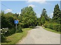
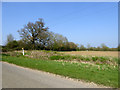
Back Street, near Ousden
A no through road leading to the quiet hamlet of Back Street.
Image: © Bob Jones
Taken: 16 Jun 2006
0.04 miles
2
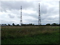
Transmitter Masts
Transmitter masts near to Genesis Green, Suffolk.
Image: © Keith Evans
Taken: 19 Sep 2010
0.10 miles
3
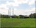
Transmission masts at Glebe Farm, Ousden
As seen from the edge of Littly Wood. The three masts stand in close proximity to each other at one of the highest spots in Suffolk (~120 metres). Their use is not known and there are no signs which would explain what purpose they serve.
Image: © Evelyn Simak
Taken: 30 Apr 2012
0.11 miles
4
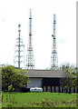
Transmission masts at Glebe Farm, Ousden
As seen from the edge of Littly Wood, with a large shed at Glebe Farm in the foreground. The three masts stand in close proximity to each other at one of the highest spots in Suffolk (~120 metres).
The tower in the background, on the left, is the Wickhambrook tower, part of a former microwave link for BBC and ITV, built about 1968. It has been used for DAB transmission since 2004. (Source: James Farrar - many thanks.) For more information read http://www.dgsys.co.uk/btmicrowave/sites/175.php.
Image: © Evelyn Simak
Taken: 30 Apr 2012
0.11 miles
5
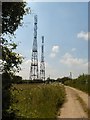
Masts at Glebe Farm
A pair of masts whose purpose is unclear. No local signs indicate ownership or usage.
Image: © Bob Jones
Taken: 16 Jun 2006
0.15 miles
6
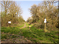
Public byway, Badmondisfield End
I forget what the signs said, but I don't think it was anything permanent.
Image: © Robin Webster
Taken: 8 Apr 2017
0.18 miles
7

Buried CLH-PS (formerly GPSS) pipeline under Back Street
According to the marker plate, an 8" oil pipeline flowing from left to right. The abbreviations on the plate indicate this is the Saffron Walden - Claydon section of the Saffron Walden - Thetford spur.
Image: © Robin Webster
Taken: 8 Apr 2017
0.19 miles
8
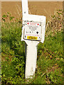
Pipeline information plate by Back Street
For an attempt to decipher this , see Image .
Image: © Robin Webster
Taken: 8 Apr 2017
0.20 miles
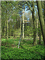
10
Pipeline route north of Back Street
The information plate on the post by the road gives details of the pipeline, but a dead give-away that this was part of the government GPSS system is the white object in the far hedgerow. This is a white stile-like structure much used to mark the pipeline routes. This route was laid in to supply East Anglian air force bases with fuel. For a detail of the marker plate see Image, and for a closer view of a 'stile' see Image, although they are more usually concrete.
Image: © Robin Webster
Taken: 8 Apr 2017
0.20 miles