1
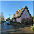
Moulton houses [10]
Number 7 School Road is a 17th century cottage, timber framed and stuccoed with a hipped, thatched roof. Listed, grade II, with details at: https://historicengland.org.uk/listing/the-list/list-entry/1374804
Moulton is a small village some 3 miles east of Newmarket and was settled in Saxon times. The River Kennett flows through the village and a 15th-century packhorse bridge spans the river.
Image: © Michael Dibb
Taken: 9 Sep 2020
0.04 miles
2
Moulton houses [9]
Number 1 School Road is a 17th century house with an early 19th century extension, Timber framed and stuccoed. Listed, grade II, with details at: https://historicengland.org.uk/listing/the-list/list-entry/1193451
Moulton is a small village some 3 miles east of Newmarket and was settled in Saxon times. The River Kennett flows through the village and a 15th-century packhorse bridge spans the river.
Image: © Michael Dibb
Taken: 9 Sep 2020
0.09 miles
3
Road junction in Moulton
Image: © Hugh Venables
Taken: 26 Jun 2021
0.10 miles
4
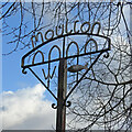
Moulton village sign
The sign is wrought iron and features the grade II* Pack Horse Bridge which spans the River Kennett. Just about wide enough for a cart it is now used only by pedestrians. A concrete ford now allows cars to cross the stream to the church. The fish represents the unusual weathervane on the church which takes the form of a large pike. The “WI” represents the Women’s Institute. https://www.geograph.org.uk/photo/6663345
Image: © Adrian S Pye
Taken: 3 Nov 2020
0.11 miles
5
Bus stop and shelter on Newmarket Road, Moulton
National Cycle Route 51.
Image: © JThomas
Taken: 21 May 2016
0.11 miles
6
Moulton houses [12]
Number 7 Bridge Street is a 17th century house, timber framed and stuccoed with a thatched roof. Listed, grade II, with details at: https://historicengland.org.uk/listing/the-list/list-entry/1193420
Moulton is a small village some 3 miles east of Newmarket and was settled in Saxon times. The River Kennett flows through the village and a 15th-century packhorse bridge spans the river.
Image: © Michael Dibb
Taken: 9 Sep 2020
0.12 miles
7
Moulton: up Bridge Street
The pretty 17th-century timber-framed cottage is Grade II listed.
Image: © John Sutton
Taken: 15 Dec 2020
0.12 miles
8
Thatched cottage, Moulton
On Bridge Street.
Image: © JThomas
Taken: 21 May 2016
0.12 miles
9
Moulton: down Bridge Street
Looking downhill from the shadows of the houses on the right past the sunlit Packhorse Inn towards the mediaeval Packhorse Bridge over the River Kennett (which someone was crossing as I pressed the shutter). The two thatched timber-framed houses are Grade II listed.
Image: © John Sutton
Taken: 15 Dec 2020
0.12 miles
10
Moulton houses [11]
Bridge Farmhouse was a farmhouse, was divided into three cottages in the late 18th or early 19th century and is now a house. There is a fragmentary 16th century core but essentially the house is mid 17th century, with 18th or 19th century alterations. Timber framed and stuccoed with a thatched roof. Listed, grade II, with details at: https://historicengland.org.uk/listing/the-list/list-entry/1193402
Moulton is a small village some 3 miles east of Newmarket and was settled in Saxon times. The River Kennett flows through the village and a 15th-century packhorse bridge spans the river.
Image: © Michael Dibb
Taken: 9 Sep 2020
0.13 miles


![Moulton houses [10]](https://s2.geograph.org.uk/geophotos/06/72/15/6721518_3337103a_120x120.jpg)
![Moulton houses [9]](https://s1.geograph.org.uk/geophotos/06/72/14/6721473_2749cbf3_120x120.jpg)


![Moulton houses [12]](https://s1.geograph.org.uk/geophotos/06/72/15/6721537_d252f951_120x120.jpg)


![Moulton houses [11]](https://s1.geograph.org.uk/geophotos/06/72/15/6721529_5104560f_120x120.jpg)