IMAGES TAKEN NEAR TO
Dalham Road, NEWMARKET, CB8 8SB
Introduction
This page details the photographs taken nearby to Dalham Road, CB8 8SB by members of the Geograph project.
The Geograph project started in 2005 with the aim of publishing, organising and preserving representative images for every square kilometre of Great Britain, Ireland and the Isle of Man.

There are currently over 7.5m images from over14,400 individuals and you can help contribute to the project by visiting https://www.geograph.org.uk
Image Map
Images are licensed for reuse under creativecommons.org/licenses/by-sa/2.0
Notes
- Clicking on the map will re-center to the selected point.
- The higher the marker number, the further away the image location is from the centre of the postcode.
Image Listing (87 Images Found)
Images are licensed for reuse under creativecommons.org/licenses/by-sa/2.0
Image
Details
Distance
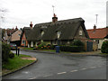
3
![Moulton houses [4]](https://s2.geograph.org.uk/geophotos/06/72/14/6721438_846223b7_120x120.jpg)
Moulton houses [4]
The delightfully named Crooked Cottage is 17th century, timber framed and stuccoed with a thatched roof. There is a 20th century extension at the rear. Listed, grade II, with details at: https://historicengland.org.uk/listing/the-list/list-entry/1374805
Moulton is a small village some 3 miles east of Newmarket and was settled in Saxon times. The River Kennett flows through the village and a 15th-century packhorse bridge spans the river.
Image: © Michael Dibb
Taken: 9 Sep 2020
0.11 miles
5
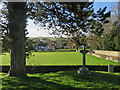
Moulton: a view from the churchyard
Looking towards the River Kennett and the southern part of the village on a bright December morning.
Image: © John Sutton
Taken: 15 Dec 2020
0.12 miles
6
![Moulton houses [5]](https://s3.geograph.org.uk/geophotos/06/72/14/6721447_8dda50c1_120x120.jpg)
Moulton houses [5]
Number 6 Church Road is set gable end to the street. Built in the late 17th or early 18th century, timber framed and stuccoed with a thatched roof. Formerly the house of the village blacksmith. Listed, grade II, with details at: https://historicengland.org.uk/listing/the-list/list-entry/1286168
Moulton is a small village some 3 miles east of Newmarket and was settled in Saxon times. The River Kennett flows through the village and a 15th-century packhorse bridge spans the river.
Image: © Michael Dibb
Taken: 9 Sep 2020
0.12 miles
7
![Moulton houses [6]](https://s0.geograph.org.uk/geophotos/06/72/14/6721452_ee20fd8b_120x120.jpg)
Moulton houses [6]
Number 2 Church Road (nearest the camera) is 19th century possibly with an earlier core. Constructed in flint rubble with gault brick quoins with a thatched roof. Listed, for group value, with details at: https://historicengland.org.uk/listing/the-list/list-entry/1193455
Number 4 Church Road is 17th or 18th century, timber framed and stuccoed with a thatched roof. Listed, grade II, with details at: https://historicengland.org.uk/listing/the-list/list-entry/1037682
Moulton is a small village some 3 miles east of Newmarket and was settled in Saxon times. The River Kennett flows through the village and a 15th-century packhorse bridge spans the river.
Image: © Michael Dibb
Taken: 9 Sep 2020
0.12 miles
8
![Moulton features [6]](https://s1.geograph.org.uk/geophotos/06/72/14/6721405_4e9aa6db_120x120.jpg)
Moulton features [6]
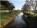
Looking from Brookside across the River Kennett to the small green and the houses in Church Road. The bridge over the river has a weight limit of three tons and there is a ford.
Moulton is a small village some 3 miles east of Newmarket and was settled in Saxon times. The River Kennett flows through the village and a 15th-century packhorse bridge spans the river.
Image: © Michael Dibb
Taken: 9 Sep 2020
0.12 miles
9
Church Road, Moulton
The long building gets two listed building entries as the right-hand half is mostly C19, the left retains more of the original C17-18 structure. The end-on cottage is similar date with the latter. All Grade II listed.
Image: © Keith Edkins
Taken: 6 Nov 2018
0.13 miles
10
![Moulton features [8]](https://s3.geograph.org.uk/geophotos/06/72/14/6721435_87638c24_120x120.jpg)
Moulton features [8]
The lane leading to the church of St Peter is closed by these fine mid 19th century wrought iron gates, with moulded cast iron piers and pedestrian and carriage gates, complete with wrought iron overthrows.
Moulton is a small village some 3 miles east of Newmarket and was settled in Saxon times. The River Kennett flows through the village and a 15th-century packhorse bridge spans the river.
Image: © Michael Dibb
Taken: 9 Sep 2020
0.13 miles