IMAGES TAKEN NEAR TO
The Dip, NEWMARKET, CB8 8AH
Introduction
This page details the photographs taken nearby to The Dip, CB8 8AH by members of the Geograph project.
The Geograph project started in 2005 with the aim of publishing, organising and preserving representative images for every square kilometre of Great Britain, Ireland and the Isle of Man.

There are currently over 7.5m images from over14,400 individuals and you can help contribute to the project by visiting https://www.geograph.org.uk
Image Map
Images are licensed for reuse under creativecommons.org/licenses/by-sa/2.0
Notes
- Clicking on the map will re-center to the selected point.
- The higher the marker number, the further away the image location is from the centre of the postcode.
Image Listing (8 Images Found)
Images are licensed for reuse under creativecommons.org/licenses/by-sa/2.0
Image
Details
Distance
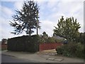
1
Centre Drive at the junction of Ashley Road
Image: © David Howard
Taken: 8 May 2017
0.06 miles
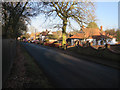
5
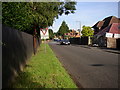
Give Way 120 Yds
Looking towards Newmarket, Suffolk along Duchess's Drive. The junction is that of B1063 and B1103
Image: © mike
Taken: 13 Sep 2005
0.17 miles
6
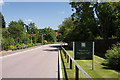
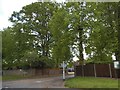
Entrance to Duchess Park
This new estate consists of executive 4- and 5-bedroomed houses and is situated east of Duchess Drive.
Image: © Bob Jones
Taken: 17 Jun 2010
0.24 miles
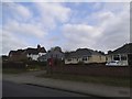
7
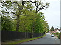
Duchess Drive, Newmarket
Houses one side and horses on the other
Image: © Richard Humphrey
Taken: 18 May 2012
0.25 miles