IMAGES TAKEN NEAR TO
Herringswell Road, NEWMARKET, CB8 7QR
Introduction
This page details the photographs taken nearby to Herringswell Road, CB8 7QR by members of the Geograph project.
The Geograph project started in 2005 with the aim of publishing, organising and preserving representative images for every square kilometre of Great Britain, Ireland and the Isle of Man.

There are currently over 7.5m images from over14,400 individuals and you can help contribute to the project by visiting https://www.geograph.org.uk
Image Map
Images are licensed for reuse under creativecommons.org/licenses/by-sa/2.0
Notes
- Clicking on the map will re-center to the selected point.
- The higher the marker number, the further away the image location is from the centre of the postcode.
Image Listing (4 Images Found)
Images are licensed for reuse under creativecommons.org/licenses/by-sa/2.0
Image
Details
Distance
1
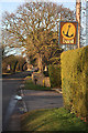
Entrance to Anchor Farm, Kentford
An interesting sign, hanging by the entrance to a farm on the Herringswell Road. The county boundary crosses the road at this point; this view is therefore from Suffolk, into Cambridgeshire.
Image: © Bob Jones
Taken: 20 Jan 2009
0.02 miles
3
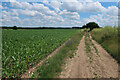
Track to Kentford Heath
This track leads eastwards from Herringswell Road. It leads to Aurelia Ltd, whose plant operator training site is situated over the hill ahead.
Image: © Bob Jones
Taken: 20 Apr 2009
0.19 miles