IMAGES TAKEN NEAR TO
Hare Park, NEWMARKET, CB8 0UZ
Introduction
This page details the photographs taken nearby to Hare Park, CB8 0UZ by members of the Geograph project.
The Geograph project started in 2005 with the aim of publishing, organising and preserving representative images for every square kilometre of Great Britain, Ireland and the Isle of Man.

There are currently over 7.5m images from over14,400 individuals and you can help contribute to the project by visiting https://www.geograph.org.uk
Image Map
Images are licensed for reuse under creativecommons.org/licenses/by-sa/2.0
Notes
- Clicking on the map will re-center to the selected point.
- The higher the marker number, the further away the image location is from the centre of the postcode.
Image Listing (7 Images Found)
Images are licensed for reuse under creativecommons.org/licenses/by-sa/2.0
Image
Details
Distance
1
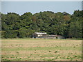
Fields and farm buildings near the A11
Image: © Keith Edkins
Taken: 19 Sep 2008
0.23 miles
2
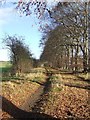
Beech Trees
Beech tree lined footpath near to Six Mile Bottom, Cambridgeshire.
Image: © Keith Evans
Taken: 28 Nov 2017
0.23 miles