IMAGES TAKEN NEAR TO
Six Mile Bottom, NEWMARKET, CB8 0UR
Introduction
This page details the photographs taken nearby to CB8 0UR by members of the Geograph project.
The Geograph project started in 2005 with the aim of publishing, organising and preserving representative images for every square kilometre of Great Britain, Ireland and the Isle of Man.

There are currently over 7.5m images from over14,400 individuals and you can help contribute to the project by visiting https://www.geograph.org.uk
Image Map
Images are licensed for reuse under creativecommons.org/licenses/by-sa/2.0
Notes
- Clicking on the map will re-center to the selected point.
- The higher the marker number, the further away the image location is from the centre of the postcode.
Image Listing (16 Images Found)
Images are licensed for reuse under creativecommons.org/licenses/by-sa/2.0
Image
Details
Distance
1
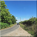
The road to Six Mile Bottom
This is the road from West Wratting to Six Mile Bottom, near Lark Hall. The signpost on the right points along a path which cuts a corner and leads to the Weston Colville road (see Image]).
Image: © John Sutton
Taken: 8 Jul 2022
0.04 miles
5
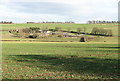
Lark Hall and Chilly Hill
Seen across the valley from Old Cambridge Road, an old route into the city from some villages to the east, now a muddy byway which ends abruptly at the A11 at Mutlow Hill.
Image: © John Sutton
Taken: 28 Jan 2011
0.09 miles
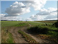
8
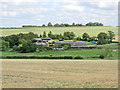
Towards Lark Hall Farm and Chilly Hill
For a winter version from more or less the same viewpoint, see Image
Image: © John Sutton
Taken: 15 Aug 2017
0.11 miles
9
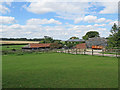
Lark Hall
A look over the hedge from the road to Six Mile Bottom.
Image: © John Sutton
Taken: 15 Aug 2017
0.12 miles
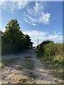
10
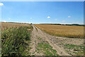
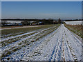
Footpath through barley
The start, near Lark Hall, of a path which follows a farm track, cutting a corner and leading to the Weston Colville road.
Image: © John Sutton
Taken: 8 Jul 2022
0.14 miles