IMAGES TAKEN NEAR TO
Cambridge Road, NEWMARKET, CB8 0TL
Introduction
This page details the photographs taken nearby to Cambridge Road, CB8 0TL by members of the Geograph project.
The Geograph project started in 2005 with the aim of publishing, organising and preserving representative images for every square kilometre of Great Britain, Ireland and the Isle of Man.

There are currently over 7.5m images from over14,400 individuals and you can help contribute to the project by visiting https://www.geograph.org.uk
Image Map
Images are licensed for reuse under creativecommons.org/licenses/by-sa/2.0
Notes
- Clicking on the map will re-center to the selected point.
- The higher the marker number, the further away the image location is from the centre of the postcode.
Image Listing (17 Images Found)
Images are licensed for reuse under creativecommons.org/licenses/by-sa/2.0
Image
Details
Distance
2
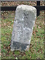
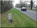
Old Milestone
Old milestone on what was the A.45 now the A.1303 near to Six Mile Bottom, Cambridgeshire. For overall view see http://www.geograph.org.uk/photo/1211563 For more info on the stone see http://milestones.megalithia.com/sites/tl599608.htm and do have a look at their home page.
Image: © Keith Evans
Taken: 19 Mar 2009
0.04 miles
4
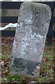
Old Milestone by the A1303, near The National Stud
Carved stone post by the A1303, in parish of Dullingham (East Cambridgeshire District), near The National Stud, on the verge, on South side of road. Great St Mary stone, erected by the Paper Mills turnpike trust in the 19th century.
Inscription reads:-
X
DULL-
INGHAM
PARISH
Cambridgeshire HER.
CHER Number: MCB18055 https://www.heritagegateway.org.uk/Gateway/Results_Single.aspx?uid=MCB18055&resourceID=1000
Milestone Society National ID: CA_CANM10
Image: © MW Hallett
Taken: 3 Jun 2002
0.06 miles
6
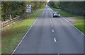
To Cambridge X (10)
Old milestone on what was the A.45 now the A.1303 near to Six Mile Bottom, Cambridgeshire. For close up view see http://www.geograph.org.uk/photo/1211569 For more info about the stone see http://milestones.megalithia.com/sites/tl599608.htm and do have a look at their home page.
Image: © Keith Evans
Taken: 19 Mar 2009
0.13 miles