IMAGES TAKEN NEAR TO
Drury Lane, ELY, CB7 5XY
Introduction
This page details the photographs taken nearby to Drury Lane, CB7 5XY by members of the Geograph project.
The Geograph project started in 2005 with the aim of publishing, organising and preserving representative images for every square kilometre of Great Britain, Ireland and the Isle of Man.

There are currently over 7.5m images from over14,400 individuals and you can help contribute to the project by visiting https://www.geograph.org.uk
Image Map
Images are licensed for reuse under creativecommons.org/licenses/by-sa/2.0
Notes
- Clicking on the map will re-center to the selected point.
- The higher the marker number, the further away the image location is from the centre of the postcode.
Image Listing (115 Images Found)
Images are licensed for reuse under creativecommons.org/licenses/by-sa/2.0
Image
Details
Distance
10
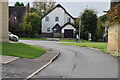
![Wicken houses [16]](https://s2.geograph.org.uk/geophotos/06/72/58/6725866_76a9ee0f_120x120.jpg)
Wicken houses [16]
Butts Farmhouse, number 15 Ponds Lane is originally a late 15th or early 16th century open hall with service and parlour ends. In the late 16th or early 17th century the parlour end was rebuilt as a crosswing and the open hall was floored. The hall is timber framed and part stuccoed with a thatched roof. The crosswing is timber framed, part exposed, with brick nogging and a thatched roof. Listed, grade II, with details at: https://historicengland.org.uk/listing/the-list/list-entry/1126429
Wicken is a small village some 10 miles north east of Cambridge and 5 miles south of Ely. There are traces of occupation from the Stone Age, Bronze Age, Roman and Anglo-Saxon periods. The village is the site of Wicken Fen National Nature Reserve.
Image: © Michael Dibb
Taken: 9 Sep 2020
0.12 miles