IMAGES TAKEN NEAR TO
Houghtons Lane, ELY, CB7 5SR
Introduction
This page details the photographs taken nearby to Houghtons Lane, CB7 5SR by members of the Geograph project.
The Geograph project started in 2005 with the aim of publishing, organising and preserving representative images for every square kilometre of Great Britain, Ireland and the Isle of Man.

There are currently over 7.5m images from over14,400 individuals and you can help contribute to the project by visiting https://www.geograph.org.uk
Image Map
Images are licensed for reuse under creativecommons.org/licenses/by-sa/2.0
Notes
- Clicking on the map will re-center to the selected point.
- The higher the marker number, the further away the image location is from the centre of the postcode.
Image Listing (5 Images Found)
Images are licensed for reuse under creativecommons.org/licenses/by-sa/2.0
Image
Details
Distance
1
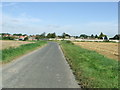
Sheldrick's Road
Entering Isleham, Cambridgeshire along Sheldrick's Road.
Image: © Keith Evans
Taken: 13 Sep 2012
0.10 miles
2
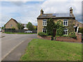
East Road, Isleham
Both types of solar panels deployed on this south-east facing roof: a solar hot water panel on the left and a photovoltaic array on the right. An array of that size will probably produce enough electricity for the house, on an annual average.
Image: © Hugh Venables
Taken: 5 May 2012
0.12 miles
3
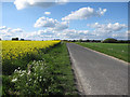
Sheldrick's Road
Heading towards Isleham past a field of oil seed rape.
Image: © Hugh Venables
Taken: 9 May 2010
0.18 miles
4
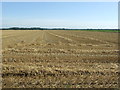
Harvested Field
A harvested field near to Isleham, Cambridgeshire.
Image: © Keith Evans
Taken: 13 Sep 2012
0.19 miles
5
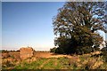
East Fen, Isleham
Looking north from East Fen Road.
Image: © Bob Jones
Taken: 1 Nov 2006
0.22 miles