IMAGES TAKEN NEAR TO
Broad Piece, ELY, CB7 5EL
Introduction
This page details the photographs taken nearby to Broad Piece, CB7 5EL by members of the Geograph project.
The Geograph project started in 2005 with the aim of publishing, organising and preserving representative images for every square kilometre of Great Britain, Ireland and the Isle of Man.

There are currently over 7.5m images from over14,400 individuals and you can help contribute to the project by visiting https://www.geograph.org.uk
Image Map
Images are licensed for reuse under creativecommons.org/licenses/by-sa/2.0
Notes
- Clicking on the map will re-center to the selected point.
- The higher the marker number, the further away the image location is from the centre of the postcode.
Image Listing (27 Images Found)
Images are licensed for reuse under creativecommons.org/licenses/by-sa/2.0
Image
Details
Distance
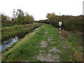
1

Path by Soham Lode
An unnavigable part of the lode, which here supports quite a lot of rushes. It is lined each side by a dyke.
For more information on lodes, see: https://en.wikipedia.org/wiki/Cambridgeshire_Lodes
Image: © Bill Boaden
Taken: 10 Dec 2018
0.12 miles
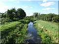
2
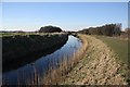
Soham Lode
A well-used path follows the eastern bank of the river, close to the village of Soham.
Image: © Bob Jones
Taken: 8 Feb 2008
0.13 miles
3
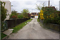
Longmere Lane
The lane is shorter than shown on the map currently due to new housing Image
Image: © Hugh Venables
Taken: 3 Jan 2010
0.13 miles
4
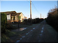
Longmere Lane, Soham
A fairly long-established private road.
Image: © Bill Boaden
Taken: 19 Apr 2015
0.14 miles
5
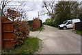
Longmere Lane, Soham
A private road leading down to Mereside.
Image: © Bill Boaden
Taken: 19 Apr 2015
0.14 miles
6
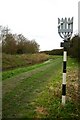
Footpath by Soham Lode
The sign by the footpath depicts an eel in the reeds. The plaque below the sign states, "Looking for the tell-tale bubbles of an eel lying low in the reeds, the Fenman would thrust his spear into the mud".
Image: © Bob Jones
Taken: 12 Dec 2006
0.15 miles
7
Footpath along Soham Lode
The footpath is shown on the 1:25000 but is covered by the railway on the 1:50000 map.
Image: © Hugh Venables
Taken: 8 Nov 2009
0.15 miles
9
Soham Lode
Downstream of Clark's Drove bridge.
Image: © Robin Webster
Taken: 6 Aug 2016
0.16 miles
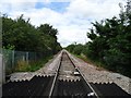
10
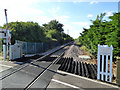
Newmarket to Ely line at crossing of Clark's Drove
Looking towards Ely. The crossing may be called Middlemere by the railway, a nearby equipment box was so labelled.
Image: © Robin Webster
Taken: 6 Aug 2016
0.16 miles