IMAGES TAKEN NEAR TO
Emperor Green, CB7 4YF
Introduction
This page details the photographs taken nearby to Emperor Green, CB7 4YF by members of the Geograph project.
The Geograph project started in 2005 with the aim of publishing, organising and preserving representative images for every square kilometre of Great Britain, Ireland and the Isle of Man.

There are currently over 7.5m images from over14,400 individuals and you can help contribute to the project by visiting https://www.geograph.org.uk
Image Map
Images are licensed for reuse under creativecommons.org/licenses/by-sa/2.0
Notes
- Clicking on the map will re-center to the selected point.
- The higher the marker number, the further away the image location is from the centre of the postcode.
Image Listing (27 Images Found)
Images are licensed for reuse under creativecommons.org/licenses/by-sa/2.0
Image
Details
Distance
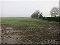
1
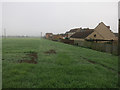
Current edge of Ely
With plans to expand Ely across the fields to the north.
Image: © Hugh Venables
Taken: 15 Nov 2014
0.03 miles
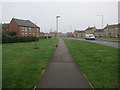
3
Longchamp Drive
Recent development on the northern edge of Ely.
Image: © Hugh Venables
Taken: 15 Nov 2014
0.08 miles
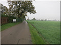
4
Current edge of Ely
More developments are planned north of the recent homes.
Image: © Hugh Venables
Taken: 15 Nov 2014
0.09 miles
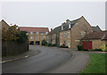
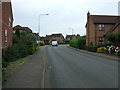
5

Kings Avenue, Ely
At the junction with Longchamp Drive
Image: © Geographer
Taken: 11 Oct 2019
0.10 miles
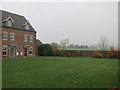
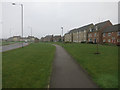
6
King's Avenue, Ely
Recent development on the northern edge of Ely.
Image: © Hugh Venables
Taken: 15 Nov 2014
0.10 miles
7
King's Avenue, Ely
Recent development on the northern edge of Ely.
Image: © Hugh Venables
Taken: 15 Nov 2014
0.11 miles
10
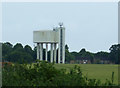
Water tower, Ely
Huge structure visible from some distance.
Image: © JThomas
Taken: 2 Jul 2015
0.14 miles