IMAGES TAKEN NEAR TO
Old Bank, ELY, CB7 4XJ
Introduction
This page details the photographs taken nearby to Old Bank, CB7 4XJ by members of the Geograph project.
The Geograph project started in 2005 with the aim of publishing, organising and preserving representative images for every square kilometre of Great Britain, Ireland and the Isle of Man.

There are currently over 7.5m images from over14,400 individuals and you can help contribute to the project by visiting https://www.geograph.org.uk
Image Map
Images are licensed for reuse under creativecommons.org/licenses/by-sa/2.0
Notes
- Clicking on the map will re-center to the selected point.
- The higher the marker number, the further away the image location is from the centre of the postcode.
Image Listing (7 Images Found)
Images are licensed for reuse under creativecommons.org/licenses/by-sa/2.0
Image
Details
Distance
1
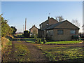
Hawthorn Farm and Bank Farm
Isolated houses near Queen Adelaide. The track is part of the Hereward Way long-distance path. Prickwillow lies ahead.
Image: © John Sutton
Taken: 5 Jan 2017
0.02 miles
2
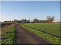
Middle Fen Bank
Three isolated houses near Queen Adelaide. The track is part of the Hereward Way long-distance path.
Image: © John Sutton
Taken: 5 Jan 2017
0.04 miles
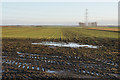
3
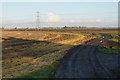
Drove on Middle Fen Bank
Part of the Hereward Way, heading towards Prickwillow. The yellow field on the left is the result of weedkiller.
Image: © Bill Boaden
Taken: 29 Nov 2019
0.07 miles
4
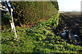
Footpath near Hawthorn Farm
Not a well-used path, but there is a better alternative. The large hedge on the left is there as a windbreak.
Image: © Bill Boaden
Taken: 29 Nov 2019
0.09 miles
5
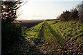
The Hereward Way near Hawthorn Farm
Looking west into low winter sun.
Image: © Bill Boaden
Taken: 29 Nov 2019
0.10 miles
7
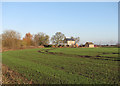
Towards Bank Farm in January
A view from the footpath from Wades Farm.
Image: © John Sutton
Taken: 5 Jan 2017
0.12 miles