IMAGES TAKEN NEAR TO
Lark Bank, ELY, CB7 4SW
Introduction
This page details the photographs taken nearby to Lark Bank, CB7 4SW by members of the Geograph project.
The Geograph project started in 2005 with the aim of publishing, organising and preserving representative images for every square kilometre of Great Britain, Ireland and the Isle of Man.

There are currently over 7.5m images from over14,400 individuals and you can help contribute to the project by visiting https://www.geograph.org.uk
Image Map
Images are licensed for reuse under creativecommons.org/licenses/by-sa/2.0
Notes
- Clicking on the map will re-center to the selected point.
- The higher the marker number, the further away the image location is from the centre of the postcode.
Image Listing (30 Images Found)
Images are licensed for reuse under creativecommons.org/licenses/by-sa/2.0
Image
Details
Distance
1
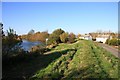
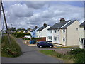
River Lark and Lark Bank
The houses at Lark Bank are below the level of the river.
Image: © Bob Jones
Taken: 9 Nov 2007
0.03 miles
3
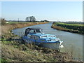
Moored Boat
Boat moored on The River Lark near to Prickwillow; Cambridgeshire.
Image: © Keith Evans
Taken: 16 Feb 2016
0.04 miles
4
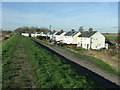
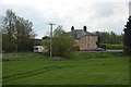
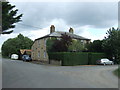
Houses
Houses at Lark Bank near to Prickwillow, Cambridgeshire.
Image: © Keith Evans
Taken: 16 Feb 2016
0.04 miles
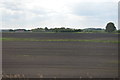
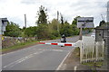
7
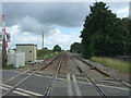
Railway towards Norwich
Looking north east from the level crossing on Mile End Road (B1382).
Image: © JThomas
Taken: 19 Aug 2017
0.20 miles