IMAGES TAKEN NEAR TO
Militia Way, ELY, CB7 4JL
Introduction
This page details the photographs taken nearby to Militia Way, CB7 4JL by members of the Geograph project.
The Geograph project started in 2005 with the aim of publishing, organising and preserving representative images for every square kilometre of Great Britain, Ireland and the Isle of Man.

There are currently over 7.5m images from over14,400 individuals and you can help contribute to the project by visiting https://www.geograph.org.uk
Image Map
Images are licensed for reuse under creativecommons.org/licenses/by-sa/2.0
Notes
- Clicking on the map will re-center to the selected point.
- The higher the marker number, the further away the image location is from the centre of the postcode.
Image Listing (1441 Images Found)
Images are licensed for reuse under creativecommons.org/licenses/by-sa/2.0
Image
Details
Distance
1
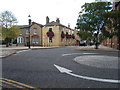
The Fountain, Ely
Name all-but-obscured by the burgeoning hanging-baskets.
Image: © Barbara Carr
Taken: 1 Oct 2009
0.00 miles
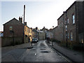
4
Silver Street, junction with Church Lane
Image: © Chris Gunns
Taken: 21 Nov 2009
0.02 miles
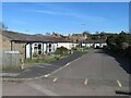
5
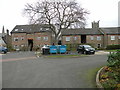
Militia Way
Block of flats backing onto Silver Street. That cathedral gets everywhere!
Image: © Keith Edkins
Taken: 6 Dec 2017
0.02 miles
7
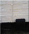
Ordnance Survey Cut Mark
This OS cut mark can be found on No17 Silver Street. It marks a point 19.053m above mean sea level.
Image: © Adrian Dust
Taken: 8 Jan 2019
0.02 miles

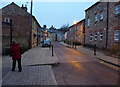
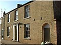
10
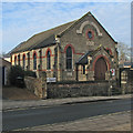
Ely: The Railway Mission, Silver Street
Built in 1901, this is now home to The Olive Tree Fellowship.
Image: © John Sutton
Taken: 17 Jan 2017
0.02 miles