IMAGES TAKEN NEAR TO
The Turnpike, ELY, CB7 4JJ
Introduction
This page details the photographs taken nearby to The Turnpike, CB7 4JJ by members of the Geograph project.
The Geograph project started in 2005 with the aim of publishing, organising and preserving representative images for every square kilometre of Great Britain, Ireland and the Isle of Man.

There are currently over 7.5m images from over14,400 individuals and you can help contribute to the project by visiting https://www.geograph.org.uk
Image Map
Images are licensed for reuse under creativecommons.org/licenses/by-sa/2.0
Notes
- Clicking on the map will re-center to the selected point.
- The higher the marker number, the further away the image location is from the centre of the postcode.
Image Listing (22 Images Found)
Images are licensed for reuse under creativecommons.org/licenses/by-sa/2.0
Image
Details
Distance
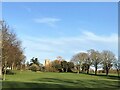
1
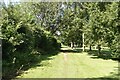
Path along the edge of Ely Golf Course
Image: © David Martin
Taken: 29 Jul 2024
0.06 miles
2
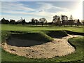
Practice bunker and green at Ely Golf Club, Cambridgeshire
The course was closed when this photo was taken thanks to strict and somewhat nonsensical lockdown rules implemented by the Tory government aimed at controlling the spread of the Covid-19 pandemic.
Image: © Richard Humphrey
Taken: 22 Nov 2020
0.07 miles
3
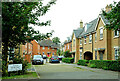
On Cambridge Road
New houses on Cambridge Road on the south side of Ely.
Image: © Mary and Angus Hogg
Taken: 1 Sep 2021
0.07 miles
5
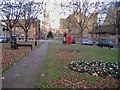
Barton Square, Ely
A "square" (actually nearer a triangle) with the buildings of King's School on two sides. Ely Cathedral is in the distance at the centre; the building behind the telephone box is the Porta, one of the school's buildings. Its gateway leads to a park through which you can walk towards the river Ouse.
Image: © Colin Attenborough
Taken: 3 Dec 2006
0.09 miles
6
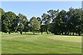
The 18th fairway at Ely Golf Club
Looking uphill towards the tee.
There is a public footpath out of shot on the left, however, straying onto the fairway on this sunny Sunday afternoon to take this photo was quite safe as the course was closed thanks to strict and somewhat nonsensical lockdown rules implemented by the Tory government aimed at controlling the spread of the Covid-19 pandemic.
Image: © Richard Humphrey
Taken: 22 Nov 2020
0.11 miles
7
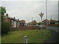
Witchford Road meets Cambridge Road
Housing on the southern outskirts of Ely.
Image: © M J Richardson
Taken: 16 May 2022
0.12 miles
8

New housing in Ely
Much development has taken place around the city in the last few years. This view is from the Cambridge Road on Ely's southern outskirt.
Image: © Jonathan Billinger
Taken: 15 Apr 2008
0.13 miles
9
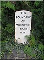
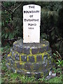
Old Boundary Marker by Witchford Road, Ely parish
Turnpike Terminus Marker by the UC road (was A142), in parish of Ely (East Cambridgeshire District), Witchford Road, on stone roundel.
Inscription reads:-
THE
BOUNDARY
OF
TURNPIKE
ROAD
1852
Surveyed
Milestone Society National ID: CA_ELY03t
Image: © Milestone Society
Taken: Unknown
0.13 miles
10
Boundary Marker
Boundary marker of the Turnpike Road Ely, Cambridgeshire for overall view see http://www.geograph.org.uk/photo/1714443
Image: © Keith Evans
Taken: 17 Feb 2010
0.14 miles