IMAGES TAKEN NEAR TO
Brooke Grove, ELY, CB6 3WS
Introduction
This page details the photographs taken nearby to Brooke Grove, CB6 3WS by members of the Geograph project.
The Geograph project started in 2005 with the aim of publishing, organising and preserving representative images for every square kilometre of Great Britain, Ireland and the Isle of Man.

There are currently over 7.5m images from over14,400 individuals and you can help contribute to the project by visiting https://www.geograph.org.uk
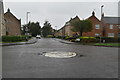
Image Map
Images are licensed for reuse under creativecommons.org/licenses/by-sa/2.0
Notes
- Clicking on the map will re-center to the selected point.
- The higher the marker number, the further away the image location is from the centre of the postcode.
Image Listing (11 Images Found)
Images are licensed for reuse under creativecommons.org/licenses/by-sa/2.0
Image
Details
Distance
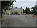
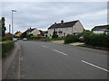
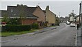
1
Beresford Road
Part of an estate built ca. 2001-2. The post box is CB6 49.
Image: © Keith Edkins
Taken: 6 Dec 2017
0.05 miles
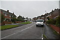
3
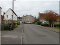
Tennyson Place
Housing off Beresford Road. The grand "house" at the far end is actually 3 dwellings, built 2001.
Image: © Keith Edkins
Taken: 6 Dec 2017
0.15 miles
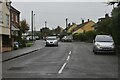
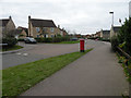
5
West Fen Road and Walsingham Way
Block of 5 flats, part of a development ca. 2010. The post box is CB6 10.
Image: © Keith Edkins
Taken: 6 Dec 2017
0.21 miles
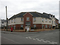
7
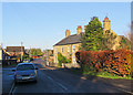
Ely: a beech hedge on West Fen Road
Near the corner of Walsingham Way on a bright November morning.
Image: © John Sutton
Taken: 23 Nov 2017
0.21 miles