IMAGES TAKEN NEAR TO
Chestnut Close, CB6 3QW
Introduction
This page details the photographs taken nearby to Chestnut Close, CB6 3QW by members of the Geograph project.
The Geograph project started in 2005 with the aim of publishing, organising and preserving representative images for every square kilometre of Great Britain, Ireland and the Isle of Man.

There are currently over 7.5m images from over14,400 individuals and you can help contribute to the project by visiting https://www.geograph.org.uk
Image Map
Images are licensed for reuse under creativecommons.org/licenses/by-sa/2.0
Notes
- Clicking on the map will re-center to the selected point.
- The higher the marker number, the further away the image location is from the centre of the postcode.
Image Listing (11 Images Found)
Images are licensed for reuse under creativecommons.org/licenses/by-sa/2.0
Image
Details
Distance
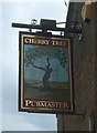
2
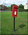
Elizabeth II postbox on Duck Lane, Haddenham
Postbox No. CB6 55.
See Image] for context.
Image: © JThomas
Taken: 12 Aug 2017
0.16 miles
3
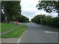
Duck Lane, Haddenham
Showing position of Postbox No. CB6 55.
See Image for postbox.
Image: © JThomas
Taken: 12 Aug 2017
0.16 miles
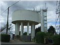
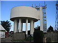
7
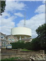
Water tower and communications mast, Haddenham
Image: © JThomas
Taken: 12 Aug 2017
0.21 miles
8
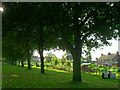
Recreation ground allotments and bordering trees, Haddenham
Image: © Andrea
Taken: 1 Oct 2014
0.21 miles
10
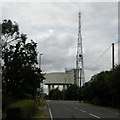
Infrastructure, Haddenham
Water Tower and Communication Mast
Image: © Keith Edkins
Taken: 17 Jul 2018
0.24 miles