IMAGES TAKEN NEAR TO
Sutton Road, ELY, CB6 3PT
Introduction
This page details the photographs taken nearby to Sutton Road, CB6 3PT by members of the Geograph project.
The Geograph project started in 2005 with the aim of publishing, organising and preserving representative images for every square kilometre of Great Britain, Ireland and the Isle of Man.

There are currently over 7.5m images from over14,400 individuals and you can help contribute to the project by visiting https://www.geograph.org.uk
Image Map
Images are licensed for reuse under creativecommons.org/licenses/by-sa/2.0
Notes
- Clicking on the map will re-center to the selected point.
- The higher the marker number, the further away the image location is from the centre of the postcode.
Image Listing (7 Images Found)
Images are licensed for reuse under creativecommons.org/licenses/by-sa/2.0
Image
Details
Distance
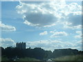
2
Site of Haddenham station
View southward from A1421 road north of the village: ex-GER Ely (to left) - St Ives (to right) branch. The modern factory has been built on the site of the former station, since 13/7/64 when goods traffic ceased Ely - Sutton although lasted three more months Sutton - St Ives. Passenger services had ceased as long ago as 2/2/31.
Image: © Ben Brooksbank
Taken: 5 Jul 1998
0.13 miles
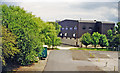
3
Route of former Sutton to Ely railway at Haddenham
Image: © Richard Humphrey
Taken: 16 May 2014
0.14 miles
4
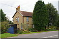
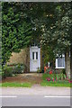
St George's Farm, Haddenham
The farmhouse hides behind two rather intimidating trees.
Image: © Ben Harris
Taken: 28 Aug 2007
0.18 miles
6
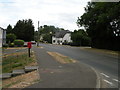
Station Road, Haddenham
The eponymous station closed in 1931! The post box is CB6 53
Image: © Keith Edkins
Taken: 17 Jul 2018
0.22 miles
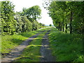
7
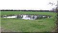
Pond in a field
View south of the North Fen Drove near St. George's Farm, Haddenham.
Image: © Jonathan Billinger
Taken: 31 Oct 2007
0.23 miles