IMAGES TAKEN NEAR TO
Hay Fen Close, ELY, CB6 3NE
Introduction
This page details the photographs taken nearby to Hay Fen Close, CB6 3NE by members of the Geograph project.
The Geograph project started in 2005 with the aim of publishing, organising and preserving representative images for every square kilometre of Great Britain, Ireland and the Isle of Man.

There are currently over 7.5m images from over14,400 individuals and you can help contribute to the project by visiting https://www.geograph.org.uk
Image Map
Images are licensed for reuse under creativecommons.org/licenses/by-sa/2.0
Notes
- Clicking on the map will re-center to the selected point.
- The higher the marker number, the further away the image location is from the centre of the postcode.
Image Listing (70 Images Found)
Images are licensed for reuse under creativecommons.org/licenses/by-sa/2.0
Image
Details
Distance
2
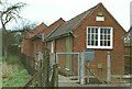
Stretham Telephone Exchange
View of the Unit Automatic Exchange (UAX) at Stretham. This was prior to going digital.
Image: © Tim Jenkins
Taken: Unknown
0.03 miles
3
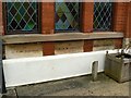
Foundation stones, Baptist Chapel, Stretham
There are 3 stones each side of the door, these are on the left. The date on all of them is July 15th 1885. The left hand stone was laid by Mr F W Savidge, the middle stone by Mrs A M Savidge and the right stone by Mr King. Charles. "James Loft & Son Builders Ely" is inscribed on the window sill.
See Image] and Image]
Image: © Rich Tea
Taken: 14 Mar 2010
0.04 miles
4
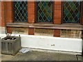
Foundation stones, Baptist Chapel, Stretham
There are 3 stones each side of the door, these are on the right. The date on all of them is July 15th 1885. The left hand stone was laid by Mrs E J Peters, the middle stone is in memory of I & F Murfitt, and the right hand stone was laid by Rev Richard Roberts on behalf of the Sunday School. "Jos. Gunton, Architect" is inscribed on the window sill.
See Image] and Image]
Image: © Rich Tea
Taken: 14 Mar 2010
0.04 miles
5
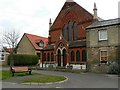
Former Methodist Chapel, Stretham
This is no longer used as a chapel, the Methodist congregation meet with the Anglican congregation now.
It was built in 1885.
See Image] and Image]
(Thanks to David Woodruff for additional information)
Image: © Rich Tea
Taken: 14 Mar 2010
0.04 miles
6
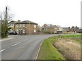
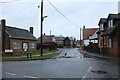
Wilburton Road, Stretham
And the junction with Chapel Street
Image: © Rich Tea
Taken: 14 Mar 2010
0.04 miles
7
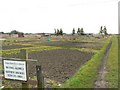
Stretham Charity Trustees Allotments
The allotments occupy a large area on the edge of the village between Wilburton Road and Green End.
Image: © Rich Tea
Taken: 14 Mar 2010
0.04 miles
8
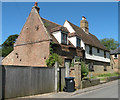
Home Farmhouse, Stretham
I believe that is the name of this building, although the listed buildings register puts it 100m further south! The farther building is originally C17 and the upper storey still timber-framed. Grade II listed.
Image: © Keith Edkins
Taken: 25 Jun 2018
0.09 miles
9
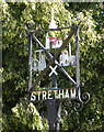
Stretham village sign
Showing the village windmill, the Old Steam Engine and its engine house
Image: © Keith Edkins
Taken: 25 Jun 2018
0.10 miles
10
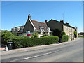
House for sale, Newmarket Road
The oldest part of this property is said to date "from the 1800's". Together with the more modern rear extension it offers 4 bedrooms, and is on the market at £325,000.
Image: © Keith Edkins
Taken: 25 Jun 2018
0.10 miles