IMAGES TAKEN NEAR TO
Hazel Court, ELY, CB6 3LY
Introduction
This page details the photographs taken nearby to Hazel Court, CB6 3LY by members of the Geograph project.
The Geograph project started in 2005 with the aim of publishing, organising and preserving representative images for every square kilometre of Great Britain, Ireland and the Isle of Man.

There are currently over 7.5m images from over14,400 individuals and you can help contribute to the project by visiting https://www.geograph.org.uk
Image Map
Images are licensed for reuse under creativecommons.org/licenses/by-sa/2.0
Notes
- Clicking on the map will re-center to the selected point.
- The higher the marker number, the further away the image location is from the centre of the postcode.
Image Listing (68 Images Found)
Images are licensed for reuse under creativecommons.org/licenses/by-sa/2.0
Image
Details
Distance
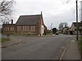
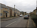
2
Stretham Community Primary School
On Wood Lane.
Image: © Hugh Venables
Taken: 30 Jan 2011
0.04 miles
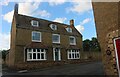
3
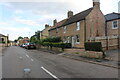
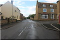
Berry Green, Stretham
Village edge housing - looking at old maps, probably 1930s
Image: © Keith Edkins
Taken: 25 Jun 2018
0.08 miles
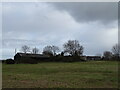
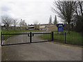
9

Track to Berry Green Farm
On the edge of Stretham.
Image: © Hugh Venables
Taken: 30 Jan 2011
0.13 miles