IMAGES TAKEN NEAR TO
Poachers Way, ELY, CB6 3GQ
Introduction
This page details the photographs taken nearby to Poachers Way, CB6 3GQ by members of the Geograph project.
The Geograph project started in 2005 with the aim of publishing, organising and preserving representative images for every square kilometre of Great Britain, Ireland and the Isle of Man.

There are currently over 7.5m images from over14,400 individuals and you can help contribute to the project by visiting https://www.geograph.org.uk
Image Map
Images are licensed for reuse under creativecommons.org/licenses/by-sa/2.0
Notes
- Clicking on the map will re-center to the selected point.
- The higher the marker number, the further away the image location is from the centre of the postcode.
Image Listing (30 Images Found)
Images are licensed for reuse under creativecommons.org/licenses/by-sa/2.0
Image
Details
Distance

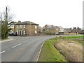
2
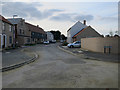
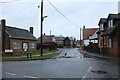
Chadwick Way, Stretham
New set of housing expanding Stretham to the east.
Image: © Hugh Venables
Taken: 25 Aug 2017
0.03 miles
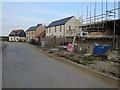
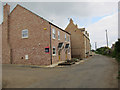
4
Petersfield, Stretham
The road was built soon after 2015 as were the houses.
Image: © David Howard
Taken: 13 Feb 2022
0.08 miles
5
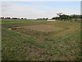
Drainage area for new housing, Stretham
Image: © Hugh Venables
Taken: 25 Aug 2017
0.08 miles
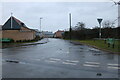
7
New housing, Stretham
There were more houses being built behind these as well.
Image: © Hugh Venables
Taken: 14 May 2011
0.12 miles
8
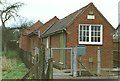
Stretham Telephone Exchange
View of the Unit Automatic Exchange (UAX) at Stretham. This was prior to going digital.
Image: © Tim Jenkins
Taken: Unknown
0.16 miles
9
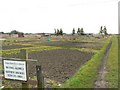
Stretham Charity Trustees Allotments
The allotments occupy a large area on the edge of the village between Wilburton Road and Green End.
Image: © Rich Tea
Taken: 14 Mar 2010
0.16 miles
10
Wilburton Road, Stretham
And the junction with Chapel Street
Image: © Rich Tea
Taken: 14 Mar 2010
0.17 miles