IMAGES TAKEN NEAR TO
West End, ELY, CB6 3AY
Introduction
This page details the photographs taken nearby to West End, CB6 3AY by members of the Geograph project.
The Geograph project started in 2005 with the aim of publishing, organising and preserving representative images for every square kilometre of Great Britain, Ireland and the Isle of Man.

There are currently over 7.5m images from over14,400 individuals and you can help contribute to the project by visiting https://www.geograph.org.uk
Image Map
Images are licensed for reuse under creativecommons.org/licenses/by-sa/2.0
Notes
- Clicking on the map will re-center to the selected point.
- The higher the marker number, the further away the image location is from the centre of the postcode.
Image Listing (124 Images Found)
Images are licensed for reuse under creativecommons.org/licenses/by-sa/2.0
Image
Details
Distance
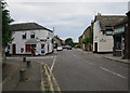
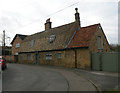
2
Ely: the corner of West End and St John's Road
The corner shop on the left is dated 1848.
Image: © John Sutton
Taken: 1 Feb 2018
0.03 miles
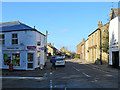
3
One Stop Shop, St Johns Road
Back in 2007 this was Image, but no longer. It still has the wall mounted post box CB6 11, though. Inscribed on the corner "St Johns Place 1848".
Image: © Keith Edkins
Taken: 6 Dec 2017
0.04 miles
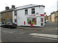
4
St John's Road Post Office
An endangered species.
Image: © Keith Edkins
Taken: 18 Oct 2007
0.04 miles

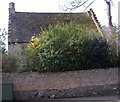
6
Cottage, Hills Lane
Originally 2 C18 brick cottages, now combined. Tiled mansard roof. Grade II listed.
Image: © Keith Edkins
Taken: 6 Dec 2017
0.06 miles

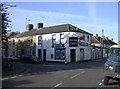
8
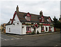
West End House
Public house in the road known simply as West End.
Image: © Keith Edkins
Taken: 6 Dec 2017
0.07 miles
9
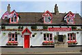
West End House, Ely
Patriotic public house bedecked in Union Jack flags and the colour scheme of St. George
Image: © Chris Heaton
Taken: 15 Aug 2024
0.07 miles
10
An old house in the St. John's area of Ely
One of a group of buildings shown as St John's Farm towards the left hand edge of
http://www.british-history.ac.uk/image.aspx?compid=21883&filename=fig02.gif
Other buildings in the group are described in
http://www.eastcambs.gov.uk/html/LBDetails.asp?field1=99
and
http://www.eastcambs.gov.uk/html/LBDetails.asp?field1=102
http://www.eastcambs.gov.uk/html/LBDetails.asp?field1=101
implies that the building in the picture is St John's Farmhouse
Image: © Colin Attenborough
Taken: 6 Apr 2007
0.08 miles