IMAGES TAKEN NEAR TO
Damson Avenue, ELY, CB6 2FN
Introduction
This page details the photographs taken nearby to Damson Avenue, CB6 2FN by members of the Geograph project.
The Geograph project started in 2005 with the aim of publishing, organising and preserving representative images for every square kilometre of Great Britain, Ireland and the Isle of Man.

There are currently over 7.5m images from over14,400 individuals and you can help contribute to the project by visiting https://www.geograph.org.uk
Image Map
Images are licensed for reuse under creativecommons.org/licenses/by-sa/2.0
Notes
- Clicking on the map will re-center to the selected point.
- The higher the marker number, the further away the image location is from the centre of the postcode.
Image Listing (16 Images Found)
Images are licensed for reuse under creativecommons.org/licenses/by-sa/2.0
Image
Details
Distance
1
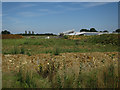
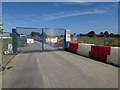
Development by Cam Drive
Isle of Ely Primary School being built before 190 houses are built as part of the Orchards Green development.
Image: © Hugh Venables
Taken: 22 Aug 2015
0.02 miles
2
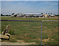
Isle of Ely Primary School
Under construction as the first step for further expansion of Ely.
Image: © Hugh Venables
Taken: 22 Aug 2015
0.04 miles
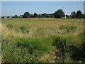
4
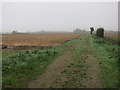
Prepared ground, North Ely
Part of the North Ely Development.
Image: © Hugh Venables
Taken: 15 Nov 2014
0.10 miles
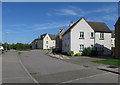
5
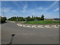
New access road
To the new school under construction.
Image: © Hugh Venables
Taken: 22 Aug 2015
0.10 miles
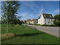
6
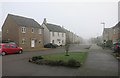
Wensum Way, Ely
New development on the northern edge of Ely.
Image: © Hugh Venables
Taken: 15 Nov 2014
0.11 miles
8
Prepared ground, North Ely
Part of the North Ely Development.
Image: © Hugh Venables
Taken: 15 Nov 2014
0.13 miles
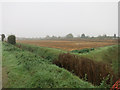
10
Cleared ground
Part of a large expansion of Ely.
Image: © Hugh Venables
Taken: 22 Aug 2015
0.13 miles