IMAGES TAKEN NEAR TO
Wayhead, ELY, CB6 2DW
Introduction
This page details the photographs taken nearby to Wayhead, CB6 2DW by members of the Geograph project.
The Geograph project started in 2005 with the aim of publishing, organising and preserving representative images for every square kilometre of Great Britain, Ireland and the Isle of Man.

There are currently over 7.5m images from over14,400 individuals and you can help contribute to the project by visiting https://www.geograph.org.uk
Image Map
Images are licensed for reuse under creativecommons.org/licenses/by-sa/2.0
Notes
- Clicking on the map will re-center to the selected point.
- The higher the marker number, the further away the image location is from the centre of the postcode.
Image Listing (9 Images Found)
Images are licensed for reuse under creativecommons.org/licenses/by-sa/2.0
Image
Details
Distance
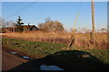
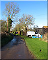
2
Way Head: passing place near Way Head Farm
Way Head is a tiny settlement in the Isle of Ely, between Coveney and Little Downham.
Image: © John Sutton
Taken: 23 Nov 2017
0.04 miles
4

Ditch between fields
The ditch looks due for a clearout as there is a large amount of vegetation in it.
Image: © Hugh Venables
Taken: 11 Jan 2009
0.12 miles
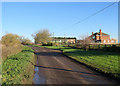
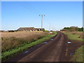
5
Way Head: drove ends
Old Lynn Drove, to the left, leads to Wardy Hill and Mepal. Straight Drove, ahead, serves farms on Coveney Byall Fen and ends at the New Bedford River.
Image: © John Sutton
Taken: 23 Nov 2017
0.17 miles
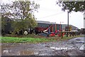
6
Way Head: Old Lynn Drove
Way Head is a remote hamlet in the Isle of Ely, between Coveney and Little Downham. This byway leads to Wardy Hill and Mepal.
Image: © John Sutton
Taken: 23 Nov 2017
0.18 miles
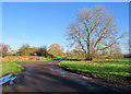
7
Way Head ahead
The approach to Way Head on the road from Coveney.
Image: © John Sutton
Taken: 23 Nov 2017
0.23 miles
8
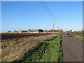
On Downham Hythe Drove near Way Head
Sea level in the Isle of Ely. There are spot heights of 1 and 2m at Way Head, in Image
Image: © John Sutton
Taken: 23 Nov 2017
0.23 miles
9

Fenland farmland
This is probably the best arable farmland in the country and there is a shortage of food and biomass (this is the first year for many years without set-aside, where farmers are paid not to grow crops to avoid oversupply across the European Union). However there is still a market for leaving maize cover crops unharvested (back left, with blue hopper for supplementary grain feeding) for rearing game birds. People then pay the farmer for the right to shoot the pheasants or partridges.
Image: © Hugh Venables
Taken: 11 Jan 2009
0.24 miles