IMAGES TAKEN NEAR TO
Oak Court, CB5 8XP
Introduction
This page details the photographs taken nearby to Oak Court, CB5 8XP by members of the Geograph project.
The Geograph project started in 2005 with the aim of publishing, organising and preserving representative images for every square kilometre of Great Britain, Ireland and the Isle of Man.

There are currently over 7.5m images from over14,400 individuals and you can help contribute to the project by visiting https://www.geograph.org.uk
Image Map
Images are licensed for reuse under creativecommons.org/licenses/by-sa/2.0
Notes
- Clicking on the map will re-center to the selected point.
- The higher the marker number, the further away the image location is from the centre of the postcode.
Image Listing (68 Images Found)
Images are licensed for reuse under creativecommons.org/licenses/by-sa/2.0
Image
Details
Distance
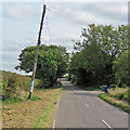
1
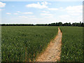
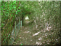
Footpath to Teversham
The well-defined path from Fen Ditton, viewed from the edge of the plantation to the south of the former course of the Cambridge to Mildenhall railway. Much of the wheatfield is in the next gridsquare to the east. With no discernible rain from February to May 2010, Cambridgeshire is one of five eastern counties officially designated drought areas, as the dry and cracked path shows.
Image: © John Sutton
Taken: 14 Jun 2011
0.05 miles
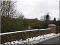
2
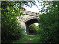
Bridge over the Cambridge-Mildenhall railway
The line closed to passengers in 1962 and to goods two years later. The skew bridge carrying the Fen Ditton to Quy road still stands, and the railway trackbed is a well-used path which ends here - north of the bridge the railway is densely overgrown (see Image]). For a view from the other side of the bridge, see Image Image] and Image] show the bridge from the road, in winter.
Image: © John Sutton
Taken: 14 Jun 2011
0.08 miles
4
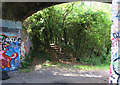
Bridge over the Mildenhall Branch
This bridge, carrying the Fen Ditton to Quy road, once crossed the Cambridge to Mildenhall railway (1884-1964). The steps ahead lead to a permissive path running parallel to the road - see Image] - and various other unmarked paths through the woodland south of the old railway line. Image] and Image] show the bridge from the road. Some of the wonderfully creative people who think bricks are enhanced by spraying have been here.
Image: © John Sutton
Taken: 14 Jun 2011
0.08 miles
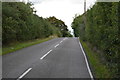
5
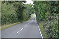
Fen Ditton: nearing the bridge on High Ditch Road
The hump bridge was built to span the Cambridge to Mildenhall branch railway (1884-1964). For a closer look at the bridge, see Image] and Image
Image: © John Sutton
Taken: 11 Sep 2020
0.09 miles
6
Old railway bridge
One of the few discernible relics of the Mildenhall branch
Image: © Keith Edkins
Taken: 30 Jan 2008
0.09 miles
8
Track of the Mildenhall Branch
The parapet of the bridge over the Cambridge to Mildenhall railway is just in this gridsquare.
Image: © John Sutton
Taken: 10 Jan 2010
0.09 miles
9
Permissive path near Fen Ditton
A dreary picture which could be anywhere - but is a well-marked permissive path, not shown on maps, linking the path along the old Cambridge-Mildenhall railway line and the Fen Ditton to Quy road, which it parallels, east of the old railway bridge.
Image: © John Sutton
Taken: 14 Jun 2011
0.09 miles
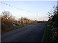
10
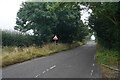
Approaching High Ditch Bridge
The bridge is just visible beyond the sign on this dull misty morning.
Image: © Malcolm Neal
Taken: 9 Sep 2021
0.09 miles